Anniston geodata
Anniston (Alabama) is a seat of a second-order administrative division; located in United States in America/Chicago (GMT-5) time zone. With population of 22,347 people, there are 2269 cities with bigger population in this country. Compared to other cities in United States, 82.3% of cities are located further ↑North; 53.3% of cities are located further ←West and 54.2% of cities have lower elevation than Anniston. Note1


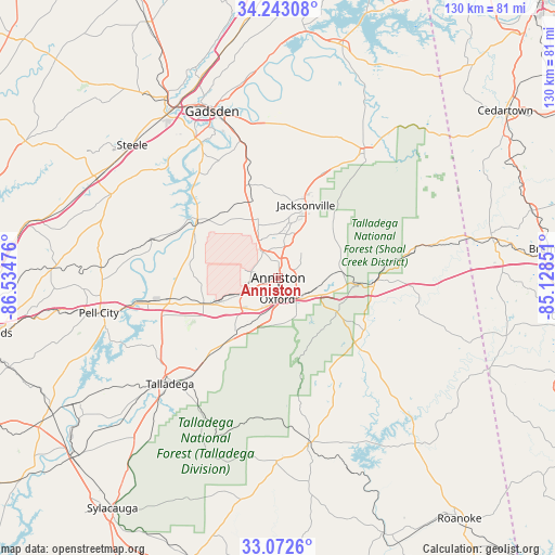
Anniston GPS coordinates[2]
33° 39' 35.388" North, 85° 49' 53.868" West
| Map corner | latitude | longitude |
|---|---|---|
| Upper-left | 34.24308°, | -86.53476° |
| Center: | 33.65983°, | -85.83163° |
| Lower-right: | 33.0726°, | -85.12851° |
| Map W x H: | 130.1×130.1 km | = 80.8×80.8mi |
| max Lat: | 71.29058° ⇑82.3% North |
| Anniston: | 33.65983° |
| min Lat: | ⇓17.7% South 19.06759° |
| min Long | Anniston | max Long |
| -171.73463° | -85.83163° | -66.98998° |
| W 53.3%⇐ | ⇒46.7% E |
Elevation
Elevation of Anniston is 215 m = 705 ft, and this is 79.8 m = 262 ft below average elevation for this country.
| Max E: |
3189 m = 10463 ft | 45.8% |
| Avg. | 294.8 m = 967 ft | |
| Anniston | 215 m = 705 ft | |
Min E: |
-60 m = -197 ft | 54.2% |
See also: United States elevation on elevation.city.
Geographical zone
Anniston is located in North temperate zone (between Tropic of Cancer and the Arctic Circle). Distance of this Northern Tropic circle is 1136.7 km =706.3 mi to South.| Distance of | km | miles | from Anniston |
|---|---|---|---|
| North Pole | 6264.4 | 3892.5 | to North |
| Arctic Circle | 3658.6 | 2273.3 | to North |
| Tropic Cancer | 1136.7 | 706.3 | to South |
| Equator | 3742.6 | 2325.5 | to South |


Nearby cities:
15 places around Anniston: (largest is in red/bold)
• Alexandria
13.6 km =8.5 mi,  338°
338°
• Bynum
13.1 km =8.1 mi,  246°
246°
• Choccolocco
11.9 km =7.4 mi,  90°
90°
• Heflin
22.6 km =14 mi, 93°
• Hobson City
4.4 km =2.7 mi,  195°
195°
• Hollis Crossroads
23.5 km =14.6 mi,  130°
130°
• Jacksonville
18.3 km =11.4 mi,  20°
20°
• Lincoln
27 km =16.8 mi,  258°
258°
• Munford
18.2 km =11.3 mi,  217°
217°
• Ohatchee
20.9 km =13 mi,  311°
311°
• Oxford
5.1 km =3.2 mi,  183°
183°
• Saks
4.4 km =2.7 mi,  350°
350°
• Weaver
10.4 km =6.5 mi,  10°
10°
• West End-Cobb Town
4 km =2.5 mi, 258°
• White Plains
16.4 km =10.2 mi,  53°
53°
Sources, notices
• [Note1] Compared only with cities in United States existing in our database
• [Src1] Map data: © OpenStreetMap contributors (CC-BY-SA)
• [Src2] Other city data from geonames.org with taken over terms of usage.
• [Src3] Geographical zone / Annual Mean Temperature by Robert A. Rohde @ Wikipedia
