West End-Cobb Town geodata
West End-Cobb Town (Alabama) is a populated place; located in United States in America/Chicago (GMT-5) time zone. With population of 3,465 people, there are 8893 cities with bigger population in this country. Compared to other cities in United States, 82.3% of cities are located further ↑North; 53.2% of cities are located further ←West and 57.5% of cities have lower elevation than West End-Cobb Town. Note1


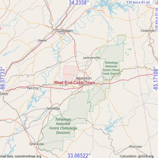
West End-Cobb Town GPS coordinates[2]
33° 39' 9" North, 85° 52' 27.12" West
| Map corner | latitude | longitude |
|---|---|---|
| Upper-left | 34.2358°, | -86.57733° |
| Center: | 33.6525°, | -85.8742° |
| Lower-right: | 33.06522°, | -85.17108° |
| Map W x H: | 130.2×130.2 km | = 80.9×80.9mi |
| max Lat: | 71.29058° ⇑82.3% North |
| West End-Cobb Town: | 33.6525° |
| min Lat: | ⇓17.7% South 19.06759° |
| min Long | West End-Cobb T | max Long |
| -171.73463° | -85.8742° | -66.98998° |
| W 53.2%⇐ | ⇒46.8% E |
Elevation
Elevation of West End-Cobb Town is 228 m = 748 ft, and this is 66.8 m = 219 ft below average elevation for this country.
| Max E: |
3189 m = 10463 ft | 42.5% |
| Avg. | 294.8 m = 967 ft | |
| West End-Cobb Town | 228 m = 748 ft | |
Min E: |
-60 m = -197 ft | 57.5% |
See also: United States elevation on elevation.city.
Geographical zone
West End-Cobb Town is located in North temperate zone (between Tropic of Cancer and the Arctic Circle). Distance of this Northern Tropic circle is 1135.9 km =705.8 mi to South.| Distance of | km | miles | from West End-Cobb Town |
|---|---|---|---|
| North Pole | 6265.3 | 3893.1 | to North |
| Arctic Circle | 3659.4 | 2273.8 | to North |
| Tropic Cancer | 1135.9 | 705.8 | to South |
| Equator | 3741.8 | 2325 | to South |


Nearby cities:
15 places around West End-Cobb Town: (largest is in red/bold)
• Alexandria
13.5 km =8.4 mi,  355°
355°
• Anniston
4 km =2.5 mi,  78°
78°
• Bynum
9.2 km =5.7 mi,  241°
241°
• Choccolocco
15.8 km =9.8 mi,  87°
87°
• Heflin
26.5 km =16.5 mi, 90°
• Hobson City
4.4 km =2.7 mi,  141°
141°
• Hollis Crossroads
26.2 km =16.3 mi,  123°
123°
• Jacksonville
20.8 km =12.9 mi,  30°
30°
• Lincoln
23 km =14.3 mi,  259°
259°
• Munford
15.4 km =9.6 mi,  207°
207°
• Ohatchee
18.8 km =11.7 mi,  320°
320°
• Oxford
5.6 km =3.5 mi, 139°
• Saks
6 km =3.7 mi, 31°
• Weaver
12.5 km =7.8 mi, 27°
• White Plains
20.1 km =12.5 mi,  58°
58°
Sources, notices
• [Note1] Compared only with cities in United States existing in our database
• [Src1] Map data: © OpenStreetMap contributors (CC-BY-SA)
• [Src2] Other city data from geonames.org with taken over terms of usage.
• [Src3] Geographical zone / Annual Mean Temperature by Robert A. Rohde @ Wikipedia
