Munford geodata
Munford (Alabama) is a populated place; located in United States in America/Chicago (GMT-5) time zone. With population of 1,259 people, there are 14798 cities with bigger population in this country. Compared to other cities in United States, 83% of cities are located further ↑North; 53% of cities are located further ←West and 51.9% of cities have higher elevation than Munford. Note1


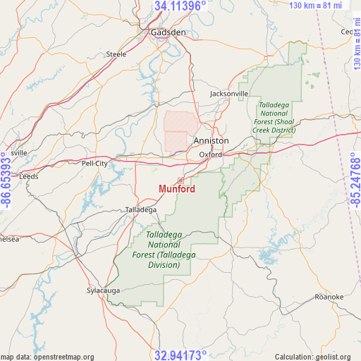
Munford GPS coordinates[2]
33° 31' 47.388" North, 85° 57' 2.88" West
| Map corner | latitude | longitude |
|---|---|---|
| Upper-left | 34.11396°, | -86.65393° |
| Center: | 33.52983°, | -85.9508° |
| Lower-right: | 32.94173°, | -85.24768° |
| Map W x H: | 130.3×130.3 km | = 81×81mi |
| max Lat: | 71.29058° ⇑83% North |
| Munford: | 33.52983° |
| min Lat: | ⇓17% South 19.06759° |
| min Long | Munford | max Long |
| -171.73463° | -85.9508° | -66.98998° |
| W 53%⇐ | ⇒47% E |
Elevation
Elevation of Munford is 191 m = 627 ft, and this is 103.8 m = 341 ft below average elevation for this country.
| Max E: |
3189 m = 10463 ft | 51.9% |
| Avg. | 294.8 m = 967 ft | |
| Munford | 191 m = 627 ft | |
Min E: |
-60 m = -197 ft | 48.1% |
See also: United States elevation on elevation.city.
Geographical zone
Munford is located in North temperate zone (between Tropic of Cancer and the Arctic Circle). Distance of this Northern Tropic circle is 1122.2 km =697.3 mi to South.| Distance of | km | miles | from Munford |
|---|---|---|---|
| North Pole | 6278.9 | 3901.5 | to North |
| Arctic Circle | 3673 | 2282.3 | to North |
| Tropic Cancer | 1122.2 | 697.3 | to South |
| Equator | 3728.2 | 2316.6 | to South |


Nearby cities:
15 places around Munford: (largest is in red/bold)
• Alexandria
27.8 km =17.3 mi,  12°
12°
• Anniston
18.2 km =11.3 mi,  37°
37°
• Bynum
9.3 km =5.8 mi,  354°
354°
• Choccolocco
27 km =16.8 mi,  57°
57°
• Hobson City
14.2 km =8.8 mi, 44°
• Hollis Crossroads
29.1 km =18.1 mi,  91°
91°
• Lincoln
18.1 km =11.2 mi,  300°
300°
• Lineville
30.4 km =18.9 mi,  143°
143°
• Ohatchee
28.6 km =17.8 mi, 350°
• Oxford
14.3 km =8.9 mi,  48°
48°
• Riverside
25 km =15.5 mi,  289°
289°
• Saks
21.4 km =13.3 mi,  28°
28°
• Talladega
17.8 km =11.1 mi,  234°
234°
• Weaver
27.9 km =17.3 mi, 27°
• West End-Cobb Town
15.4 km =9.6 mi, 27°
Sources, notices
• [Note1] Compared only with cities in United States existing in our database
• [Src1] Map data: © OpenStreetMap contributors (CC-BY-SA)
• [Src2] Other city data from geonames.org with taken over terms of usage.
• [Src3] Geographical zone / Annual Mean Temperature by Robert A. Rohde @ Wikipedia
