Glendale Heights geodata
Glendale Heights (Illinois) is a populated place; located in United States in America/Chicago (GMT-5) time zone. With population of 34,208 people, there are 1438 cities with bigger population in this country. Compared to other cities in United States, 74.9% of cities are located further ↓South; 53.1% of cities are located further →East and 57.2% of cities have lower elevation than Glendale Heights. Note1
Administrative division(s):
- Level 1: Illinois
- Level 2: DuPage County
- Level 3: Township of Bloomingdale


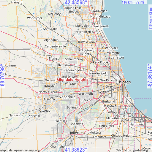
Glendale Heights GPS coordinates[2]
41° 54' 52.56" North, 88° 3' 53.496" West
| Map corner | latitude | longitude |
|---|---|---|
| Upper-left | 42.43568°, | -88.76799° |
| Center: | 41.9146°, | -88.06486° |
| Lower-right: | 41.38923°, | -87.36174° |
| Map W x H: | 116.4×116.4 km | = 72.3×72.3mi |
| max Lat: | 71.29058° ⇑25.1% North |
| Glendale Heights: | 41.9146° |
| min Lat: | ⇓74.9% South 19.06759° |
| min Long | Glendale Height | max Long |
| -171.73463° | -88.06486° | -66.98998° |
| W 46.9%⇐ | ⇒53.1% E |
Elevation
Elevation of Glendale Heights is 227 m = 745 ft, and this is 67.8 m = 222 ft below average elevation for this country.
| Max E: |
3189 m = 10463 ft | 42.8% |
| Avg. | 294.8 m = 967 ft | |
| Glendale Heights | 227 m = 745 ft | |
Min E: |
-60 m = -197 ft | 57.2% |
See also: United States elevation on elevation.city.
Geographical zone
Glendale Heights is located in North temperate zone (between Tropic of Cancer and the Arctic Circle). Distance of this Northern Tropic circle is 2054.5 km =1276.6 mi to South.| Distance of | km | miles | from Glendale Heights |
|---|---|---|---|
| North Pole | 5346.6 | 3322.2 | to North |
| Arctic Circle | 2740.7 | 1703 | to North |
| Tropic Cancer | 2054.5 | 1276.6 | to South |
| Equator | 4660.5 | 2895.9 | to South |


Nearby cities:
15 places around Glendale Heights: (largest is in red/bold)
• Addison
6.6 km =4.1 mi,  73°
73°
• Bensenville
11.3 km =7 mi, 66°
• Bloomingdale
5 km =3.1 mi,  344°
344°
• Carol Stream
5.8 km =3.6 mi,  267°
267°
• Elmhurst
10.4 km =6.5 mi,  99°
99°
• Glen Ellyn
4.1 km =2.5 mi,  182°
182°
• Hanover Park
11.5 km =7.1 mi,  324°
324°
• Itasca
8.2 km =5.1 mi,  35°
35°
• Lombard
6.1 km =3.8 mi,  129°
129°
• Oakbrook Terrace
11 km =6.8 mi, 130°
• Roselle
7.9 km =4.9 mi,  351°
351°
• Villa Park
6.9 km =4.3 mi,  113°
113°
• Wheaton
6.4 km =4 mi,  212°
212°
• Winfield
9.9 km =6.2 mi,  233°
233°
• Wood Dale
8.9 km =5.5 mi,  52°
52°
Sources, notices
• [Note1] Compared only with cities in United States existing in our database
• [Src1] Map data: © OpenStreetMap contributors (CC-BY-SA)
• [Src2] Other city data from geonames.org with taken over terms of usage.
• [Src3] Geographical zone / Annual Mean Temperature by Robert A. Rohde @ Wikipedia
