Wheaton geodata
Wheaton (Illinois) is a seat of a second-order administrative division; located in United States in America/Chicago (GMT-5) time zone. With population of 53,715 people, there are 868 cities with bigger population in this country. Compared to other cities in United States, 74.5% of cities are located further ↓South; 53.4% of cities are located further →East and 58.6% of cities have lower elevation than Wheaton. Note1


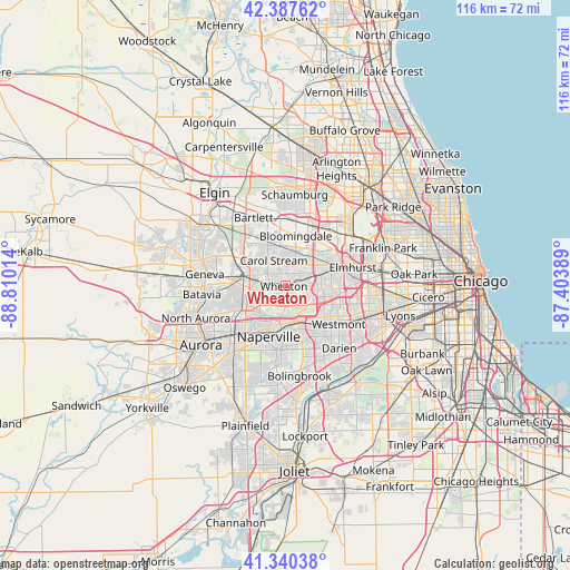
Wheaton GPS coordinates[2]
41° 51' 58.104" North, 88° 6' 25.236" West
| Map corner | latitude | longitude |
|---|---|---|
| Upper-left | 42.38762°, | -88.81014° |
| Center: | 41.86614°, | -88.10701° |
| Lower-right: | 41.34038°, | -87.40389° |
| Map W x H: | 116.4×116.4 km | = 72.3×72.3mi |
| max Lat: | 71.29058° ⇑25.5% North |
| Wheaton: | 41.86614° |
| min Lat: | ⇓74.5% South 19.06759° |
| min Long | Wheaton | max Long |
| -171.73463° | -88.10701° | -66.98998° |
| W 46.6%⇐ | ⇒53.4% E |
Elevation
Elevation of Wheaton is 233 m = 764 ft, and this is 61.8 m = 203 ft below average elevation for this country.
| Max E: |
3189 m = 10463 ft | 41.4% |
| Avg. | 294.8 m = 967 ft | |
| Wheaton | 233 m = 764 ft | |
Min E: |
-60 m = -197 ft | 58.6% |
See also: Wheaton elevation on elevation.city.
Geographical zone
Wheaton is located in North temperate zone (between Tropic of Cancer and the Arctic Circle). Distance of this Northern Tropic circle is 2049.2 km =1273.3 mi to South.| Distance of | km | miles | from Wheaton |
|---|---|---|---|
| North Pole | 5352 | 3325.6 | to North |
| Arctic Circle | 2746.1 | 1706.3 | to North |
| Tropic Cancer | 2049.2 | 1273.3 | to South |
| Equator | 4655.1 | 2892.5 | to South |


Nearby cities:
15 places around Wheaton: (largest is in red/bold)
• Addison
12.2 km =7.6 mi,  53°
53°
• Bloomingdale
10.4 km =6.5 mi,  12°
12°
• Carol Stream
5.6 km =3.5 mi,  335°
335°
• Downers Grove
10.2 km =6.3 mi,  128°
128°
• Glen Ellyn
3.5 km =2.2 mi,  69°
69°
• Glendale Heights
6.4 km =4 mi,  32°
32°
• Lisle
7.7 km =4.8 mi,  159°
159°
• Lombard
8.4 km =5.2 mi,  79°
79°
• Naperville
9.5 km =5.9 mi,  200°
200°
• Oakbrook Terrace
11.9 km =7.4 mi,  98°
98°
• Roselle
13.4 km =8.3 mi, 9°
• Villa Park
10.1 km =6.3 mi, 74°
• Warrenville
7.7 km =4.8 mi,  225°
225°
• West Chicago
8.3 km =5.2 mi,  284°
284°
• Winfield
4.5 km =2.8 mi,  263°
263°
Sources, notices
• [Note1] Compared only with cities in United States existing in our database
• [Src1] Map data: © OpenStreetMap contributors (CC-BY-SA)
• [Src2] Other city data from geonames.org with taken over terms of usage.
• [Src3] Geographical zone / Annual Mean Temperature by Robert A. Rohde @ Wikipedia
