Guilford geodata
Guilford (Connecticut) is a populated place; located in United States in America/New_York (GMT-4) time zone. With population of 22,498 people, there are 2252 cities with bigger population in this country. Compared to other cities in United States, 68.7% of cities are located further ↓South; 94.4% of cities are located further ←West and 93% of cities have higher elevation than Guilford. Note1
Administrative division(s):
- Level 1: Connecticut
- Level 2: New Haven County
- Level 3: Town of Guilford


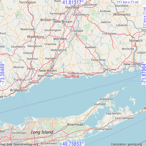
Guilford GPS coordinates[2]
41° 17' 20.364" North, 72° 40' 54.336" West
| Map corner | latitude | longitude |
|---|---|---|
| Upper-left | 41.81517°, | -73.38489° |
| Center: | 41.28899°, | -72.68176° |
| Lower-right: | 40.75853°, | -71.97864° |
| Map W x H: | 117.5×117.5 km | = 73×73mi |
| max Lat: | 71.29058° ⇑31.3% North |
| Guilford: | 41.28899° |
| min Lat: | ⇓68.7% South 19.06759° |
| min Long | Guilford | max Long |
| -171.73463° | -72.68176° | -66.98998° |
| W 94.4%⇐ | ⇒5.6% E |
Elevation
Elevation of Guilford is 11 m = 36 ft, and this is 283.8 m = 931 ft below average elevation for this country.
| Max E: |
3189 m = 10463 ft | 93% |
| Avg. | 294.8 m = 967 ft | |
| Guilford | 11 m = 36 ft | |
Min E: |
-60 m = -197 ft | 7% |
See also: United States elevation on elevation.city.
Geographical zone
Guilford is located in North temperate zone (between Tropic of Cancer and the Arctic Circle). Distance of this Northern Tropic circle is 1985 km =1233.4 mi to South.| Distance of | km | miles | from Guilford |
|---|---|---|---|
| North Pole | 5416.2 | 3365.5 | to North |
| Arctic Circle | 2810.3 | 1746.2 | to North |
| Tropic Cancer | 1985 | 1233.4 | to South |
| Equator | 4590.9 | 2852.7 | to South |


Nearby cities:
15 places around Guilford: (largest is in red/bold)
• Branford
11.2 km =7 mi,  264°
264°
• Branford Center
11.2 km =7 mi, 263°
• Clinton
12.9 km =8 mi,  95°
95°
• Durham
21.4 km =13.3 mi,  0°
0°
• East Haven
15.7 km =9.8 mi, 264°
• Guilford Center
0.9 km =0.6 mi,  150°
150°
• Hamden
21.5 km =13.4 mi,  303°
303°
• Madison
7 km =4.3 mi, 98°
• Madison Center
6.9 km =4.3 mi, 99°
• New Haven
20.7 km =12.9 mi,  275°
275°
• North Branford
8.3 km =5.2 mi, 300°
• North Haven
18.7 km =11.6 mi,  307°
307°
• Wallingford
22.1 km =13.7 mi,  327°
327°
• Wallingford Center
21.2 km =13.2 mi, 327°
• Westbrook Center
20 km =12.4 mi,  92°
92°
Sources, notices
• [Note1] Compared only with cities in United States existing in our database
• [Src1] Map data: © OpenStreetMap contributors (CC-BY-SA)
• [Src2] Other city data from geonames.org with taken over terms of usage.
• [Src3] Geographical zone / Annual Mean Temperature by Robert A. Rohde @ Wikipedia
