Milford geodata
Milford (Connecticut) is a populated place; located in United States in America/New_York (GMT-4) time zone. With population of 52,759 people, there are 882 cities with bigger population in this country. Compared to other cities in United States, 68% of cities are located further ↓South; 93.8% of cities are located further ←West and 91.5% of cities have higher elevation than Milford. Note1


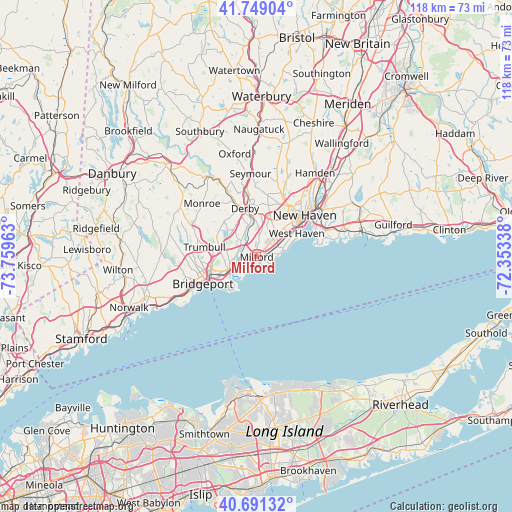
Milford GPS coordinates[2]
41° 13' 20.352" North, 73° 3' 23.4" West
| Map corner | latitude | longitude |
|---|---|---|
| Upper-left | 41.74904°, | -73.75963° |
| Center: | 41.22232°, | -73.0565° |
| Lower-right: | 40.69132°, | -72.35338° |
| Map W x H: | 117.6×117.6 km | = 73.1×73.1mi |
| max Lat: | 71.29058° ⇑32% North |
| Milford: | 41.22232° |
| min Lat: | ⇓68% South 19.06759° |
| min Long | Milford | max Long |
| -171.73463° | -73.0565° | -66.98998° |
| W 93.8%⇐ | ⇒6.2% E |
Elevation
Elevation of Milford is 13 m = 43 ft, and this is 281.8 m = 925 ft below average elevation for this country.
| Max E: |
3189 m = 10463 ft | 91.5% |
| Avg. | 294.8 m = 967 ft | |
| Milford | 13 m = 43 ft | |
Min E: |
-60 m = -197 ft | 8.5% |
See also: Milford elevation on elevation.city.
Geographical zone
Milford is located in North temperate zone (between Tropic of Cancer and the Arctic Circle). Distance of this Northern Tropic circle is 1977.6 km =1228.8 mi to South.| Distance of | km | miles | from Milford |
|---|---|---|---|
| North Pole | 5423.6 | 3370.1 | to North |
| Arctic Circle | 2817.7 | 1750.8 | to North |
| Tropic Cancer | 1977.6 | 1228.8 | to South |
| Equator | 4583.5 | 2848.1 | to South |


Nearby cities:
15 places around Milford: (largest is in red/bold)
• Ansonia
13.9 km =8.6 mi,  352°
352°
• Bridgeport
12.1 km =7.5 mi,  246°
246°
• City of Milford (balance)
0.5 km =0.3 mi,  290°
290°
• Derby
11.3 km =7 mi, 346°
• East Haven
16.8 km =10.4 mi,  69°
69°
• Fairfield
19.5 km =12.1 mi,  242°
242°
• New Haven
14.4 km =8.9 mi,  48°
48°
• Orange
6.8 km =4.2 mi,  22°
22°
• Seymour
19.5 km =12.1 mi,  355°
355°
• Shelton
10.9 km =6.8 mi,  343°
343°
• Stratford
7.7 km =4.8 mi, 236°
• Trumbull
12.3 km =7.6 mi,  280°
280°
• West Haven
10.6 km =6.6 mi,  59°
59°
• Woodbridge
15 km =9.3 mi, 15°
• Woodmont
5.5 km =3.4 mi,  83°
83°
Sources, notices
• [Note1] Compared only with cities in United States existing in our database
• [Src1] Map data: © OpenStreetMap contributors (CC-BY-SA)
• [Src2] Other city data from geonames.org with taken over terms of usage.
• [Src3] Geographical zone / Annual Mean Temperature by Robert A. Rohde @ Wikipedia
