Stratford geodata
Stratford (Connecticut) is a populated place; located in United States in America/New_York (GMT-4) time zone. With population of 51,384 people, there are 925 cities with bigger population in this country. Compared to other cities in United States, 67.7% of cities are located further ↓South; 93.6% of cities are located further ←West and 94.8% of cities have higher elevation than Stratford. Note1
Administrative division(s):
- Level 1: Connecticut
- Level 2: Fairfield County
- Level 3: Town of Stratford


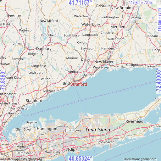
Stratford GPS coordinates[2]
41° 11' 4.344" North, 73° 7' 59.412" West
| Map corner | latitude | longitude |
|---|---|---|
| Upper-left | 41.71157°, | -73.8363° |
| Center: | 41.18454°, | -73.13317° |
| Lower-right: | 40.65324°, | -72.43005° |
| Map W x H: | 117.7×117.7 km | = 73.1×73.1mi |
| max Lat: | 71.29058° ⇑32.3% North |
| Stratford: | 41.18454° |
| min Lat: | ⇓67.7% South 19.06759° |
| min Long | Stratford | max Long |
| -171.73463° | -73.13317° | -66.98998° |
| W 93.6%⇐ | ⇒6.4% E |
Elevation
Elevation of Stratford is 9 m = 30 ft, and this is 285.8 m = 938 ft below average elevation for this country.
| Max E: |
3189 m = 10463 ft | 94.8% |
| Avg. | 294.8 m = 967 ft | |
| Stratford | 9 m = 30 ft | |
Min E: |
-60 m = -197 ft | 5.2% |
See also: Stratford elevation on elevation.city.
Geographical zone
Stratford is located in North temperate zone (between Tropic of Cancer and the Arctic Circle). Distance of this Northern Tropic circle is 1973.4 km =1226.2 mi to South.| Distance of | km | miles | from Stratford |
|---|---|---|---|
| North Pole | 5427.8 | 3372.7 | to North |
| Arctic Circle | 2821.9 | 1753.4 | to North |
| Tropic Cancer | 1973.4 | 1226.2 | to South |
| Equator | 4579.3 | 2845.4 | to South |


Nearby cities:
15 places around Stratford: (largest is in red/bold)
• Ansonia
18.5 km =11.5 mi,  14°
14°
• Bridgeport
4.7 km =2.9 mi,  262°
262°
• City of Milford (balance)
7.4 km =4.6 mi,  53°
53°
• Derby
15.6 km =9.7 mi, 13°
• Easton
15.7 km =9.8 mi,  298°
298°
• Fairfield
11.9 km =7.4 mi,  246°
246°
• Milford
7.7 km =4.8 mi,  56°
56°
• Orange
13.8 km =8.6 mi,  40°
40°
• Shelton
15 km =9.3 mi, 12°
• Southport
13.7 km =8.5 mi, 246°
• Trumbull
8.6 km =5.3 mi,  318°
318°
• West Haven
18.3 km =11.4 mi, 58°
• Westport
19.4 km =12.1 mi, 255°
• Woodbridge
21.4 km =13.3 mi,  29°
29°
• Woodmont
12.8 km =8 mi,  67°
67°
Sources, notices
• [Note1] Compared only with cities in United States existing in our database
• [Src1] Map data: © OpenStreetMap contributors (CC-BY-SA)
• [Src2] Other city data from geonames.org with taken over terms of usage.
• [Src3] Geographical zone / Annual Mean Temperature by Robert A. Rohde @ Wikipedia
