Shelton geodata
Shelton (Connecticut) is a populated place; located in United States in America/New_York (GMT-4) time zone. With population of 41,296 people, there are 1161 cities with bigger population in this country. Compared to other cities in United States, 69% of cities are located further ↓South; 93.7% of cities are located further ←West and 91.5% of cities have higher elevation than Shelton. Note1


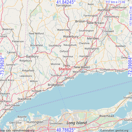
Shelton GPS coordinates[2]
41° 18' 59.364" North, 73° 5' 35.376" West
| Map corner | latitude | longitude |
|---|---|---|
| Upper-left | 41.84245°, | -73.79629° |
| Center: | 41.31649°, | -73.09316° |
| Lower-right: | 40.78625°, | -72.39004° |
| Map W x H: | 117.4×117.4 km | = 72.9×72.9mi |
| max Lat: | 71.29058° ⇑31% North |
| Shelton: | 41.31649° |
| min Lat: | ⇓69% South 19.06759° |
| min Long | Shelton | max Long |
| -171.73463° | -73.09316° | -66.98998° |
| W 93.7%⇐ | ⇒6.3% E |
Elevation
Elevation of Shelton is 13 m = 43 ft, and this is 281.8 m = 925 ft below average elevation for this country.
| Max E: |
3189 m = 10463 ft | 91.5% |
| Avg. | 294.8 m = 967 ft | |
| Shelton | 13 m = 43 ft | |
Min E: |
-60 m = -197 ft | 8.5% |
See also: Shelton elevation on elevation.city.
Geographical zone
Shelton is located in North temperate zone (between Tropic of Cancer and the Arctic Circle). Distance of this Northern Tropic circle is 1988 km =1235.3 mi to South.| Distance of | km | miles | from Shelton |
|---|---|---|---|
| North Pole | 5413.1 | 3363.5 | to North |
| Arctic Circle | 2807.2 | 1744.3 | to North |
| Tropic Cancer | 1988 | 1235.3 | to South |
| Equator | 4594 | 2854.6 | to South |


Nearby cities:
15 places around Shelton: (largest is in red/bold)
• Ansonia
3.5 km =2.2 mi,  19°
19°
• Bridgeport
17.3 km =10.7 mi,  207°
207°
• City of Milford (balance)
10.6 km =6.6 mi,  165°
165°
• Derby
0.6 km =0.4 mi,  36°
36°
• Easton
18.5 km =11.5 mi,  247°
247°
• Milford
10.9 km =6.8 mi,  163°
163°
• New Haven
13.8 km =8.6 mi,  93°
93°
• Orange
7.1 km =4.4 mi,  126°
126°
• Oxford
13.2 km =8.2 mi,  351°
351°
• Seymour
9 km =5.6 mi,  9°
9°
• Stratford
15 km =9.3 mi,  192°
192°
• Trumbull
12.2 km =7.6 mi,  227°
227°
• West Haven
13.2 km =8.2 mi,  112°
112°
• Woodbridge
8.1 km =5 mi,  60°
60°
• Woodmont
13 km =8.1 mi,  139°
139°
Sources, notices
• [Note1] Compared only with cities in United States existing in our database
• [Src1] Map data: © OpenStreetMap contributors (CC-BY-SA)
• [Src2] Other city data from geonames.org with taken over terms of usage.
• [Src3] Geographical zone / Annual Mean Temperature by Robert A. Rohde @ Wikipedia
