Salem geodata
Salem (Connecticut) is a populated place; located in United States in America/New_York (GMT-4) time zone. With population of 4,183 people, there are 8012 cities with bigger population in this country. Compared to other cities in United States, 70.8% of cities are located further ↓South; 95.3% of cities are located further ←West and 68.5% of cities have higher elevation than Salem. Note1


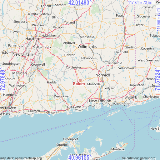
Salem GPS coordinates[2]
41° 29' 25.368" North, 72° 16' 31.296" West
| Map corner | latitude | longitude |
|---|---|---|
| Upper-left | 42.01493°, | -72.97849° |
| Center: | 41.49038°, | -72.27536° |
| Lower-right: | 40.96155°, | -71.57224° |
| Map W x H: | 117.1×117.1 km | = 72.8×72.8mi |
| max Lat: | 71.29058° ⇑29.2% North |
| Salem: | 41.49038° |
| min Lat: | ⇓70.8% South 19.06759° |
| min Long | Salem | max Long |
| -171.73463° | -72.27536° | -66.98998° |
| W 95.3%⇐ | ⇒4.7% E |
Elevation
Elevation of Salem is 110 m = 361 ft, and this is 184.8 m = 606 ft below average elevation for this country.
| Max E: |
3189 m = 10463 ft | 68.5% |
| Avg. | 294.8 m = 967 ft | |
| Salem | 110 m = 361 ft | |
Min E: |
-60 m = -197 ft | 31.5% |
See also: United States elevation on elevation.city.
Geographical zone
Salem is located in North temperate zone (between Tropic of Cancer and the Arctic Circle). Distance of this Northern Tropic circle is 2007.4 km =1247.3 mi to South.| Distance of | km | miles | from Salem |
|---|---|---|---|
| North Pole | 5393.8 | 3351.6 | to North |
| Arctic Circle | 2787.9 | 1732.3 | to North |
| Tropic Cancer | 2007.4 | 1247.3 | to South |
| Equator | 4613.3 | 2866.6 | to South |


Nearby cities:
15 places around Salem: (largest is in red/bold)
• Central Waterford
20.2 km =12.6 mi,  143°
143°
• Chester Center
17.8 km =11.1 mi,  236°
236°
• Colchester
10.6 km =6.6 mi,  333°
333°
• Deep River Center
18.2 km =11.3 mi,  228°
228°
• East Haddam
16 km =9.9 mi,  255°
255°
• Essex Village
17.8 km =11.1 mi,  212°
212°
• Gales Ferry
17.5 km =10.9 mi,  112°
112°
• Hebron
20.1 km =12.5 mi,  337°
337°
• Montville Center
10.4 km =6.5 mi,  96°
96°
• Moodus
14.6 km =9.1 mi,  275°
275°
• Niantic
19.6 km =12.2 mi,  159°
159°
• Norwich
17 km =10.6 mi,  77°
77°
• Oxoboxo River
13.5 km =8.4 mi, 112°
• Uncasville
15.1 km =9.4 mi, 114°
• Waterford
20.2 km =12.6 mi, 144°
Sources, notices
• [Note1] Compared only with cities in United States existing in our database
• [Src1] Map data: © OpenStreetMap contributors (CC-BY-SA)
• [Src2] Other city data from geonames.org with taken over terms of usage.
• [Src3] Geographical zone / Annual Mean Temperature by Robert A. Rohde @ Wikipedia
