Montville Center geodata
Montville Center (Connecticut) is a populated place; located in United States in America/New_York (GMT-4) time zone. With population of 20,180 people, there are 2492 cities with bigger population in this country. Compared to other cities in United States, 70.6% of cities are located further ↓South; 95.4% of cities are located further ←West and 66.4% of cities have higher elevation than Montville Center. Note1
Administrative division(s):
- Level 1: Connecticut
- Level 2: New London County
- Level 3: Town of Montville


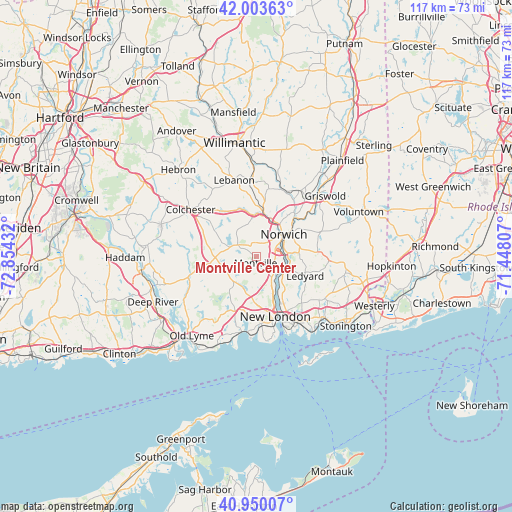
Montville Center GPS coordinates[2]
41° 28' 44.364" North, 72° 9' 4.284" West
| Map corner | latitude | longitude |
|---|---|---|
| Upper-left | 42.00363°, | -72.85432° |
| Center: | 41.47899°, | -72.15119° |
| Lower-right: | 40.95007°, | -71.44807° |
| Map W x H: | 117.1×117.1 km | = 72.8×72.8mi |
| max Lat: | 71.29058° ⇑29.4% North |
| Montville Center: | 41.47899° |
| min Lat: | ⇓70.6% South 19.06759° |
| min Long | Montville Cente | max Long |
| -171.73463° | -72.15119° | -66.98998° |
| W 95.4%⇐ | ⇒4.6% E |
Elevation
Elevation of Montville Center is 121 m = 397 ft, and this is 173.8 m = 570 ft below average elevation for this country.
| Max E: |
3189 m = 10463 ft | 66.4% |
| Avg. | 294.8 m = 967 ft | |
| Montville Center | 121 m = 397 ft | |
Min E: |
-60 m = -197 ft | 33.6% |
See also: United States elevation on elevation.city.
Geographical zone
Montville Center is located in North temperate zone (between Tropic of Cancer and the Arctic Circle). Distance of this Northern Tropic circle is 2006.1 km =1246.5 mi to South.| Distance of | km | miles | from Montville Center |
|---|---|---|---|
| North Pole | 5395 | 3352.3 | to North |
| Arctic Circle | 2789.1 | 1733.1 | to North |
| Tropic Cancer | 2006.1 | 1246.5 | to South |
| Equator | 4612 | 2865.8 | to South |


Nearby cities:
15 places around Montville Center: (largest is in red/bold)
• Baltic
16.3 km =10.1 mi,  19°
19°
• Central Waterford
15 km =9.3 mi,  173°
173°
• Conning Towers-Nautilus Park
12.5 km =7.8 mi,  146°
146°
• Gales Ferry
7.9 km =4.9 mi,  133°
133°
• Groton
15.6 km =9.7 mi,  157°
157°
• Ledyard
12.2 km =7.6 mi,  110°
110°
• Long Hill
16.2 km =10.1 mi, 149°
• New London
14.4 km =8.9 mi, 162°
• Niantic
17.4 km =10.8 mi,  191°
191°
• Norwich
8 km =5 mi,  51°
51°
• Oxoboxo River
4.5 km =2.8 mi, 150°
• Preston City
15.8 km =9.8 mi,  69°
69°
• Salem
10.4 km =6.5 mi,  276°
276°
• Uncasville
6 km =3.7 mi, 145°
• Waterford
15.3 km =9.5 mi,  175°
175°
Sources, notices
• [Note1] Compared only with cities in United States existing in our database
• [Src1] Map data: © OpenStreetMap contributors (CC-BY-SA)
• [Src2] Other city data from geonames.org with taken over terms of usage.
• [Src3] Geographical zone / Annual Mean Temperature by Robert A. Rohde @ Wikipedia
