Colchester geodata
Colchester (Connecticut) is a populated place; located in United States in America/New_York (GMT-4) time zone. With population of 4,781 people, there are 7365 cities with bigger population in this country. Compared to other cities in United States, 71.6% of cities are located further ↓South; 95.2% of cities are located further ←West and 61.7% of cities have higher elevation than Colchester. Note1
Administrative division(s):
- Level 1: Connecticut
- Level 2: New London County
- Level 3: Town of Colchester


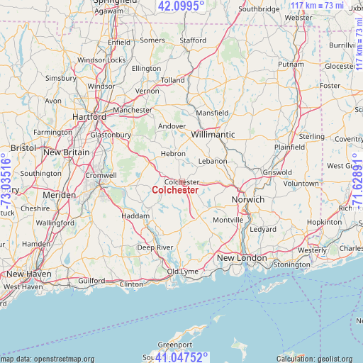
Colchester GPS coordinates[2]
41° 34' 32.34" North, 72° 19' 55.308" West
| Map corner | latitude | longitude |
|---|---|---|
| Upper-left | 42.0995°, | -73.03516° |
| Center: | 41.57565°, | -72.33203° |
| Lower-right: | 41.04752°, | -71.62891° |
| Map W x H: | 117×117 km | = 72.7×72.7mi |
| max Lat: | 71.29058° ⇑28.4% North |
| Colchester: | 41.57565° |
| min Lat: | ⇓71.6% South 19.06759° |
| min Long | Colchester | max Long |
| -171.73463° | -72.33203° | -66.98998° |
| W 95.2%⇐ | ⇒4.8% E |
Elevation
Elevation of Colchester is 146 m = 479 ft, and this is 148.8 m = 488 ft below average elevation for this country.
| Max E: |
3189 m = 10463 ft | 61.7% |
| Avg. | 294.8 m = 967 ft | |
| Colchester | 146 m = 479 ft | |
Min E: |
-60 m = -197 ft | 38.3% |
See also: United States elevation on elevation.city.
Geographical zone
Colchester is located in North temperate zone (between Tropic of Cancer and the Arctic Circle). Distance of this Northern Tropic circle is 2016.9 km =1253.2 mi to South.| Distance of | km | miles | from Colchester |
|---|---|---|---|
| North Pole | 5384.3 | 3345.6 | to North |
| Arctic Circle | 2778.4 | 1726.4 | to North |
| Tropic Cancer | 2016.9 | 1253.2 | to South |
| Equator | 4622.8 | 2872.5 | to South |


Nearby cities:
15 places around Colchester: (largest is in red/bold)
• Baltic
21.1 km =13.1 mi,  77°
77°
• Chester Center
21.8 km =13.5 mi,  207°
207°
• East Haddam
17.4 km =10.8 mi,  218°
218°
• East Hampton
14.2 km =8.8 mi,  270°
270°
• Hebron
9.6 km =6 mi,  342°
342°
• Higganum
20.7 km =12.9 mi,  244°
244°
• Lake Pocotopaug
15 km =9.3 mi,  279°
279°
• Montville Center
18.5 km =11.5 mi,  125°
125°
• Moodus
12.7 km =7.9 mi,  230°
230°
• Salem
10.6 km =6.6 mi,  153°
153°
• South Coventry
21.7 km =13.5 mi,  5°
5°
• South Windham
17.7 km =11 mi,  49°
49°
• Terramuggus
13.3 km =8.3 mi,  299°
299°
• Willimantic
18.2 km =11.3 mi,  34°
34°
• Windham
20.1 km =12.5 mi, 46°
Sources, notices
• [Note1] Compared only with cities in United States existing in our database
• [Src1] Map data: © OpenStreetMap contributors (CC-BY-SA)
• [Src2] Other city data from geonames.org with taken over terms of usage.
• [Src3] Geographical zone / Annual Mean Temperature by Robert A. Rohde @ Wikipedia
