Norwich geodata
Norwich (Connecticut) is a populated place; located in United States in America/New_York (GMT-4) time zone. With population of 39,899 people, there are 1212 cities with bigger population in this country. Compared to other cities in United States, 71.1% of cities are located further ↓South; 95.6% of cities are located further ←West and 91% of cities have higher elevation than Norwich. Note1
Administrative division(s):
- Level 1: Connecticut
- Level 2: New London County
- Level 3: Town of Norwich


Norwich GPS coordinates[2]
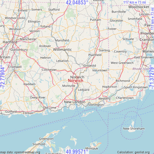
41° 31' 27.336" North, 72° 4' 33.276" West
| Map corner | latitude | longitude |
|---|---|---|
| Upper-left | 42.04853°, | -72.77904° |
| Center: | 41.52426°, | -72.07591° |
| Lower-right: | 40.99571°, | -71.37279° |
| Map W x H: | 117.1×117.1 km | = 72.8×72.8mi |
| max Lat: | 71.29058° ⇑28.9% North |
| Norwich: | 41.52426° |
| min Lat: | ⇓71.1% South 19.06759° |
| min Long | Norwich | max Long |
| -171.73463° | -72.07591° | -66.98998° |
| W 95.6%⇐ | ⇒4.4% E |
Elevation
Elevation of Norwich is 14 m = 46 ft, and this is 280.8 m = 921 ft below average elevation for this country.
| Max E: |
3189 m = 10463 ft | 91% |
| Avg. | 294.8 m = 967 ft | |
| Norwich | 14 m = 46 ft | |
Min E: |
-60 m = -197 ft | 9% |
See also: United States elevation on elevation.city.
Geographical zone
Norwich is located in North temperate zone (between Tropic of Cancer and the Arctic Circle). Distance of this Northern Tropic circle is 2011.1 km =1249.6 mi to South.| Distance of | km | miles | from Norwich |
|---|---|---|---|
| North Pole | 5390 | 3349.2 | to North |
| Arctic Circle | 2784.1 | 1730 | to North |
| Tropic Cancer | 2011.1 | 1249.6 | to South |
| Equator | 4617.1 | 2868.9 | to South |


Nearby cities:
15 places around Norwich: (largest is in red/bold)
• Baltic
10.3 km =6.4 mi,  356°
356°
• Conning Towers-Nautilus Park
15.4 km =9.6 mi,  177°
177°
• Gales Ferry
10.5 km =6.5 mi, 182°
• Jewett City
12.1 km =7.5 mi,  40°
40°
• Ledyard
10.7 km =6.6 mi,  151°
151°
• Lisbon
10.3 km =6.4 mi,  31°
31°
• Long Hill
19 km =11.8 mi,  174°
174°
• Montville Center
8 km =5 mi,  231°
231°
• New London
18.9 km =11.7 mi,  185°
185°
• Old Mystic
17.6 km =10.9 mi, 147°
• Oxoboxo River
9.8 km =6.1 mi,  204°
204°
• Preston City
8.5 km =5.3 mi,  86°
86°
• Salem
17 km =10.6 mi,  257°
257°
• South Windham
19 km =11.8 mi,  335°
335°
• Uncasville
10.4 km =6.5 mi, 195°
Sources, notices
• [Note1] Compared only with cities in United States existing in our database
• [Src1] Map data: © OpenStreetMap contributors (CC-BY-SA)
• [Src2] Other city data from geonames.org with taken over terms of usage.
• [Src3] Geographical zone / Annual Mean Temperature by Robert A. Rohde @ Wikipedia
