Easton geodata
Easton (Connecticut) is a populated place; located in United States in America/New_York (GMT-4) time zone. With population of 7,625 people, there are 5461 cities with bigger population in this country. Compared to other cities in United States, 68.3% of cities are located further ↓South; 93.2% of cities are located further ←West and 66.2% of cities have higher elevation than Easton. Note1


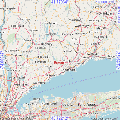
Easton GPS coordinates[2]
41° 15' 10.332" North, 73° 17' 50.424" West
| Map corner | latitude | longitude |
|---|---|---|
| Upper-left | 41.77934°, | -74.00047° |
| Center: | 41.25287°, | -73.29734° |
| Lower-right: | 40.72212°, | -72.59422° |
| Map W x H: | 117.6×117.6 km | = 73.1×73.1mi |
| max Lat: | 71.29058° ⇑31.7% North |
| Easton: | 41.25287° |
| min Lat: | ⇓68.3% South 19.06759° |
| min Long | Easton | max Long |
| -171.73463° | -73.29734° | -66.98998° |
| W 93.2%⇐ | ⇒6.8% E |
Elevation
Elevation of Easton is 122 m = 400 ft, and this is 172.8 m = 567 ft below average elevation for this country.
| Max E: |
3189 m = 10463 ft | 66.2% |
| Avg. | 294.8 m = 967 ft | |
| Easton | 122 m = 400 ft | |
Min E: |
-60 m = -197 ft | 33.8% |
See also: United States elevation on elevation.city.
Geographical zone
Easton is located in North temperate zone (between Tropic of Cancer and the Arctic Circle). Distance of this Northern Tropic circle is 1981 km =1230.9 mi to South.| Distance of | km | miles | from Easton |
|---|---|---|---|
| North Pole | 5420.2 | 3368 | to North |
| Arctic Circle | 2814.3 | 1748.7 | to North |
| Tropic Cancer | 1981 | 1230.9 | to South |
| Equator | 4586.9 | 2850.2 | to South |


Nearby cities:
15 places around Easton: (largest is in red/bold)
• Bethel
16.4 km =10.2 mi,  323°
323°
• Bridgeport
12.2 km =7.6 mi,  132°
132°
• Derby
19 km =11.8 mi,  66°
66°
• East Norwalk
18.4 km =11.4 mi,  207°
207°
• Fairfield
12.7 km =7.9 mi,  167°
167°
• Georgetown
11.5 km =7.1 mi,  271°
271°
• Newtown
17.9 km =11.1 mi,  358°
358°
• Norwalk
17.7 km =11 mi, 211°
• Ridgefield
17.1 km =10.6 mi,  280°
280°
• Shelton
18.5 km =11.5 mi, 67°
• Southport
13 km =8.1 mi, 174°
• Stratford
15.7 km =9.8 mi,  118°
118°
• Trumbull
8.2 km =5.1 mi,  97°
97°
• Westport
13.4 km =8.3 mi,  202°
202°
• Wilton
13.4 km =8.3 mi,  241°
241°
Sources, notices
• [Note1] Compared only with cities in United States existing in our database
• [Src1] Map data: © OpenStreetMap contributors (CC-BY-SA)
• [Src2] Other city data from geonames.org with taken over terms of usage.
• [Src3] Geographical zone / Annual Mean Temperature by Robert A. Rohde @ Wikipedia
