Thomaston geodata
Thomaston (Connecticut) is a populated place; located in United States in America/New_York (GMT-4) time zone. With population of 1,910 people, there are 12200 cities with bigger population in this country. Compared to other cities in United States, 72.6% of cities are located further ↓South; 93.8% of cities are located further ←West and 66.6% of cities have higher elevation than Thomaston. Note1
Administrative division(s):
- Level 1: Connecticut
- Level 2: Litchfield County
- Level 3: Town of Thomaston


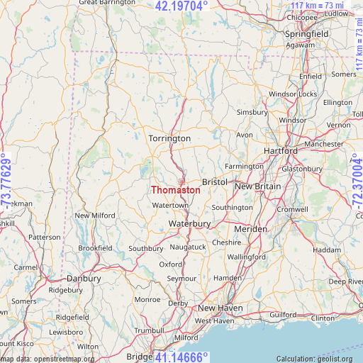
Thomaston GPS coordinates[2]
41° 40' 26.364" North, 73° 4' 23.376" West
| Map corner | latitude | longitude |
|---|---|---|
| Upper-left | 42.19704°, | -73.77629° |
| Center: | 41.67399°, | -73.07316° |
| Lower-right: | 41.14666°, | -72.37004° |
| Map W x H: | 116.8×116.8 km | = 72.6×72.6mi |
| max Lat: | 71.29058° ⇑27.4% North |
| Thomaston: | 41.67399° |
| min Lat: | ⇓72.6% South 19.06759° |
| min Long | Thomaston | max Long |
| -171.73463° | -73.07316° | -66.98998° |
| W 93.8%⇐ | ⇒6.2% E |
Elevation
Elevation of Thomaston is 120 m = 394 ft, and this is 174.8 m = 573 ft below average elevation for this country.
| Max E: |
3189 m = 10463 ft | 66.6% |
| Avg. | 294.8 m = 967 ft | |
| Thomaston | 120 m = 394 ft | |
Min E: |
-60 m = -197 ft | 33.4% |
See also: United States elevation on elevation.city.
Geographical zone
Thomaston is located in North temperate zone (between Tropic of Cancer and the Arctic Circle). Distance of this Northern Tropic circle is 2027.8 km =1260 mi to South.| Distance of | km | miles | from Thomaston |
|---|---|---|---|
| North Pole | 5373.3 | 3338.8 | to North |
| Arctic Circle | 2767.5 | 1719.6 | to North |
| Tropic Cancer | 2027.8 | 1260 | to South |
| Equator | 4633.7 | 2879.2 | to South |


Nearby cities:
15 places around Thomaston: (largest is in red/bold)
• Bantam
14.7 km =9.1 mi,  292°
292°
• Bethlehem Village
11.4 km =7.1 mi,  250°
250°
• Bristol
10.3 km =6.4 mi,  91°
91°
• Litchfield
12.6 km =7.8 mi,  310°
310°
• Middlebury
16.9 km =10.5 mi,  195°
195°
• Northwest Harwinton
11.4 km =7.1 mi,  357°
357°
• Oakville
9 km =5.6 mi,  186°
186°
• Plainville
17.9 km =11.1 mi, 89°
• Plymouth
1.7 km =1.1 mi,  97°
97°
• Terryville
5.2 km =3.2 mi,  84°
84°
• Torrington
14.6 km =9.1 mi,  344°
344°
• Waterbury
13 km =8.1 mi,  172°
172°
• Watertown
8.4 km =5.2 mi,  206°
206°
• West Torrington
17.1 km =10.6 mi, 339°
• Wolcott
10.7 km =6.6 mi,  137°
137°
Sources, notices
• [Note1] Compared only with cities in United States existing in our database
• [Src1] Map data: © OpenStreetMap contributors (CC-BY-SA)
• [Src2] Other city data from geonames.org with taken over terms of usage.
• [Src3] Geographical zone / Annual Mean Temperature by Robert A. Rohde @ Wikipedia
