Bristol geodata
Bristol (Connecticut) is a populated place; located in United States in America/New_York (GMT-4) time zone. With population of 60,452 people, there are 735 cities with bigger population in this country. Compared to other cities in United States, 72.6% of cities are located further ↓South; 94% of cities are located further ←West and 70.9% of cities have higher elevation than Bristol. Note1


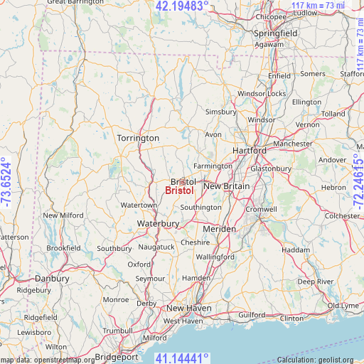
Bristol GPS coordinates[2]
41° 40' 18.336" North, 72° 56' 57.372" West
| Map corner | latitude | longitude |
|---|---|---|
| Upper-left | 42.19483°, | -73.6524° |
| Center: | 41.67176°, | -72.94927° |
| Lower-right: | 41.14441°, | -72.24615° |
| Map W x H: | 116.8×116.8 km | = 72.6×72.6mi |
| max Lat: | 71.29058° ⇑27.4% North |
| Bristol: | 41.67176° |
| min Lat: | ⇓72.6% South 19.06759° |
| min Long | Bristol | max Long |
| -171.73463° | -72.94927° | -66.98998° |
| W 94%⇐ | ⇒6% E |
Elevation
Elevation of Bristol is 95 m = 312 ft, and this is 199.8 m = 656 ft below average elevation for this country.
| Max E: |
3189 m = 10463 ft | 70.9% |
| Avg. | 294.8 m = 967 ft | |
| Bristol | 95 m = 312 ft | |
Min E: |
-60 m = -197 ft | 29.1% |
See also: Bristol elevation on elevation.city.
Geographical zone
Bristol is located in North temperate zone (between Tropic of Cancer and the Arctic Circle). Distance of this Northern Tropic circle is 2027.5 km =1259.8 mi to South.| Distance of | km | miles | from Bristol |
|---|---|---|---|
| North Pole | 5373.6 | 3339 | to North |
| Arctic Circle | 2767.7 | 1719.8 | to North |
| Tropic Cancer | 2027.5 | 1259.8 | to South |
| Equator | 4633.5 | 2879.1 | to South |


Nearby cities:
15 places around Bristol: (largest is in red/bold)
• Canton Valley
18.7 km =11.6 mi,  14°
14°
• Collinsville
15.9 km =9.9 mi, 8°
• Farmington
11.1 km =6.9 mi,  61°
61°
• Kensington
15.5 km =9.6 mi,  105°
105°
• New Britain
14.1 km =8.8 mi,  94°
94°
• Newington
19 km =11.8 mi,  81°
81°
• Northwest Harwinton
15.9 km =9.9 mi,  317°
317°
• Oakville
14.3 km =8.9 mi,  232°
232°
• Plainville
7.6 km =4.7 mi, 87°
• Plymouth
8.6 km =5.3 mi,  270°
270°
• Terryville
5.2 km =3.2 mi,  277°
277°
• Thomaston
10.3 km =6.4 mi, 271°
• Waterbury
15.2 km =9.4 mi,  213°
213°
• Watertown
15.8 km =9.8 mi,  242°
242°
• Wolcott
8.3 km =5.2 mi,  201°
201°
Sources, notices
• [Note1] Compared only with cities in United States existing in our database
• [Src1] Map data: © OpenStreetMap contributors (CC-BY-SA)
• [Src2] Other city data from geonames.org with taken over terms of usage.
• [Src3] Geographical zone / Annual Mean Temperature by Robert A. Rohde @ Wikipedia
