Northwest Harwinton geodata
Northwest Harwinton (Connecticut) is a populated place; located in United States in America/New_York (GMT-4) time zone. With population of 3,252 people, there are 9226 cities with bigger population in this country. Compared to other cities in United States, 73.7% of cities are located further ↓South; 93.7% of cities are located further ←West and 71.8% of cities have lower elevation than Northwest Harwinton. Note1
Administrative division(s):
- Level 1: Connecticut
- Level 2: Litchfield County
- Level 3: Town of Harwinton


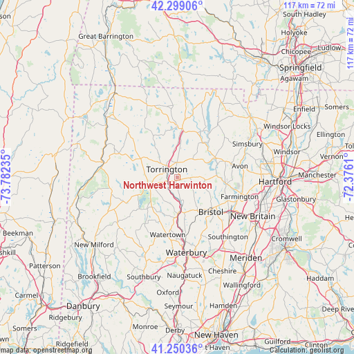
Northwest Harwinton GPS coordinates[2]
41° 46' 36.66" North, 73° 4' 45.192" West
| Map corner | latitude | longitude |
|---|---|---|
| Upper-left | 42.29906°, | -73.78235° |
| Center: | 41.77685°, | -73.07922° |
| Lower-right: | 41.25036°, | -72.3761° |
| Map W x H: | 116.6×116.6 km | = 72.5×72.5mi |
| max Lat: | 71.29058° ⇑26.3% North |
| Northwest Harwinton: | 41.77685° |
| min Lat: | ⇓73.7% South 19.06759° |
| min Long | Northwest Harwi | max Long |
| -171.73463° | -73.07922° | -66.98998° |
| W 93.7%⇐ | ⇒6.3% E |
Elevation
Elevation of Northwest Harwinton is 295 m = 968 ft, and this is 0.19999999999999 m = 1 ft above average elevation for this country.
| Max E: |
3189 m = 10463 ft | 28.2% |
| Northwest Harwinton | 295 m 968 ft | |
| Avg. | 294.8 m = 967 ft | |
Min E: |
-60 m = -197 ft | 71.8% |
See also: United States elevation on elevation.city.
Geographical zone
Northwest Harwinton is located in North temperate zone (between Tropic of Cancer and the Arctic Circle). Distance of this Northern Tropic circle is 2039.2 km =1267.1 mi to South.| Distance of | km | miles | from Northwest Harwinton |
|---|---|---|---|
| North Pole | 5361.9 | 3331.7 | to North |
| Arctic Circle | 2756 | 1712.5 | to North |
| Tropic Cancer | 2039.2 | 1267.1 | to South |
| Equator | 4645.2 | 2886.4 | to South |


Nearby cities:
15 places around Northwest Harwinton: (largest is in red/bold)
• Bantam
14.3 km =8.9 mi,  245°
245°
• Bethlehem Village
18.4 km =11.4 mi,  214°
214°
• Bristol
15.9 km =9.9 mi,  137°
137°
• Canton Valley
16.8 km =10.4 mi,  67°
67°
• Collinsville
13.8 km =8.6 mi, 73°
• Litchfield
9.7 km =6 mi, 250°
• New Hartford Center
14.3 km =8.9 mi,  36°
36°
• Plymouth
11.9 km =7.4 mi,  169°
169°
• Terryville
12.4 km =7.7 mi,  152°
152°
• Thomaston
11.4 km =7.1 mi,  177°
177°
• Torrington
4.4 km =2.7 mi,  307°
307°
• Watertown
19.2 km =11.9 mi,  189°
189°
• West Torrington
7.1 km =4.4 mi, 310°
• Winchester Center
14.5 km =9 mi,  341°
341°
• Winsted
16.1 km =10 mi,  5°
5°
Sources, notices
• [Note1] Compared only with cities in United States existing in our database
• [Src1] Map data: © OpenStreetMap contributors (CC-BY-SA)
• [Src2] Other city data from geonames.org with taken over terms of usage.
• [Src3] Geographical zone / Annual Mean Temperature by Robert A. Rohde @ Wikipedia
