Slater geodata
Slater (Iowa) is a populated place; located in United States in America/Chicago (GMT-5) time zone. With population of 1,506 people, there are 13631 cities with bigger population in this country. Compared to other cities in United States, 74.6% of cities are located further ↓South; 68% of cities are located further →East and 74.9% of cities have lower elevation than Slater. Note1


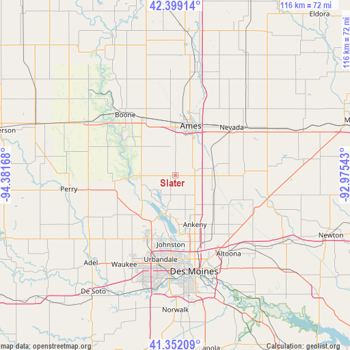
Slater GPS coordinates[2]
41° 52' 39.936" North, 93° 40' 42.78" West
| Map corner | latitude | longitude |
|---|---|---|
| Upper-left | 42.39914°, | -94.38168° |
| Center: | 41.87776°, | -93.67855° |
| Lower-right: | 41.35209°, | -92.97543° |
| Map W x H: | 116.4×116.4 km | = 72.3×72.3mi |
| max Lat: | 71.29058° ⇑25.4% North |
| Slater: | 41.87776° |
| min Lat: | ⇓74.6% South 19.06759° |
| min Long | Slater | max Long |
| -171.73463° | -93.67855° | -66.98998° |
| W 32%⇐ | ⇒68% E |
Elevation
Elevation of Slater is 312 m = 1024 ft, and this is 17.2 m = 56 ft above average elevation for this country.
| Max E: |
3189 m = 10463 ft | 25.1% |
| Slater | 312 m 1024 ft | |
| Avg. | 294.8 m = 967 ft | |
Min E: |
-60 m = -197 ft | 74.9% |
See also: United States elevation on elevation.city.
Geographical zone
Slater is located in North temperate zone (between Tropic of Cancer and the Arctic Circle). Distance of this Northern Tropic circle is 2050.5 km =1274.1 mi to South.| Distance of | km | miles | from Slater |
|---|---|---|---|
| North Pole | 5350.7 | 3324.8 | to North |
| Arctic Circle | 2744.8 | 1705.5 | to North |
| Tropic Cancer | 2050.5 | 1274.1 | to South |
| Equator | 4656.4 | 2893.4 | to South |


Nearby cities:
15 places around Slater: (largest is in red/bold)
• Ames
18.1 km =11.2 mi,  15°
15°
• Ankeny
17.5 km =10.9 mi,  159°
159°
• Cambridge
12.6 km =7.8 mi,  79°
79°
• Elkhart
16.1 km =10 mi,  126°
126°
• Gilbert
25.6 km =15.9 mi,  5°
5°
• Granger
17.7 km =11 mi,  222°
222°
• Grimes
23 km =14.3 mi,  203°
203°
• Huxley
6.7 km =4.2 mi,  73°
73°
• Johnston
22.8 km =14.2 mi,  183°
183°
• Madrid
12 km =7.5 mi,  269°
269°
• Maxwell
23.1 km =14.4 mi,  86°
86°
• Nevada
24.7 km =15.3 mi,  49°
49°
• Polk City
12.2 km =7.6 mi,  193°
193°
• Saylorville
22.5 km =14 mi,  169°
169°
• Woodward
20.3 km =12.6 mi,  263°
263°
Sources, notices
• [Note1] Compared only with cities in United States existing in our database
• [Src1] Map data: © OpenStreetMap contributors (CC-BY-SA)
• [Src2] Other city data from geonames.org with taken over terms of usage.
• [Src3] Geographical zone / Annual Mean Temperature by Robert A. Rohde @ Wikipedia
