Batavia geodata
Batavia (Iowa) is a populated place; located in United States in America/Chicago (GMT-5) time zone. With population of 516 people, there are 20683 cities with bigger population in this country. Compared to other cities in United States, 65.8% of cities are located further ↓South; 64.5% of cities are located further →East and 57.9% of cities have lower elevation than Batavia. Note1
Administrative division(s):
- Level 1: Iowa
- Level 2: Jefferson County
- Level 3: Township of Locust Grove


Batavia GPS coordinates[2]
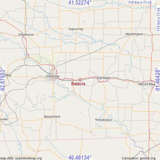
40° 59' 39.048" North, 92° 10' 2.64" West
| Map corner | latitude | longitude |
|---|---|---|
| Upper-left | 41.52274°, | -92.87053° |
| Center: | 40.99418°, | -92.1674° |
| Lower-right: | 40.46134°, | -91.46428° |
| Map W x H: | 118×118 km | = 73.3×73.3mi |
| max Lat: | 71.29058° ⇑34.2% North |
| Batavia: | 40.99418° |
| min Lat: | ⇓65.8% South 19.06759° |
| min Long | Batavia | max Long |
| -171.73463° | -92.1674° | -66.98998° |
| W 35.5%⇐ | ⇒64.5% E |
Elevation
Elevation of Batavia is 230 m = 755 ft, and this is 64.8 m = 213 ft below average elevation for this country.
| Max E: |
3189 m = 10463 ft | 42.1% |
| Avg. | 294.8 m = 967 ft | |
| Batavia | 230 m = 755 ft | |
Min E: |
-60 m = -197 ft | 57.9% |
See also: United States elevation on elevation.city.
Geographical zone
Batavia is located in North temperate zone (between Tropic of Cancer and the Arctic Circle). Distance of this Northern Tropic circle is 1952.2 km =1213 mi to South.| Distance of | km | miles | from Batavia |
|---|---|---|---|
| North Pole | 5448.9 | 3385.8 | to North |
| Arctic Circle | 2843 | 1766.6 | to North |
| Tropic Cancer | 1952.2 | 1213 | to South |
| Equator | 4558.1 | 2832.3 | to South |


Nearby cities:
15 places around Batavia: (largest is in red/bold)
• Agency
11.7 km =7.3 mi,  270°
270°
• Bloomfield
34.1 km =21.2 mi,  217°
217°
• Brighton
35.4 km =22 mi,  55°
55°
• Eddyville
43.3 km =26.9 mi,  294°
294°
• Eldon
9.6 km =6 mi,  209°
209°
• Fairfield
17.3 km =10.7 mi,  84°
84°
• Fremont
33.1 km =20.6 mi,  317°
317°
• Hedrick
23.1 km =14.4 mi,  329°
329°
• Keosauqua
34 km =21.1 mi,  149°
149°
• Keota
44.8 km =27.8 mi,  23°
23°
• Maharishi Vedic City
15.9 km =9.9 mi,  65°
65°
• Ottumwa
20.7 km =12.9 mi,  277°
277°
• Richland
25.8 km =16 mi,  34°
34°
• Sigourney
37.8 km =23.5 mi,  355°
355°
• Wayland
45.8 km =28.5 mi, 68°
Sources, notices
• [Note1] Compared only with cities in United States existing in our database
• [Src1] Map data: © OpenStreetMap contributors (CC-BY-SA)
• [Src2] Other city data from geonames.org with taken over terms of usage.
• [Src3] Geographical zone / Annual Mean Temperature by Robert A. Rohde @ Wikipedia
