Keosauqua geodata
Keosauqua (Iowa) is a seat of a second-order administrative division; located in United States in America/Chicago (GMT-5) time zone. With population of 947 people, there are 16661 cities with bigger population in this country. Compared to other cities in United States, 62% of cities are located further ↓South; 64% of cities are located further →East and 55.3% of cities have higher elevation than Keosauqua. Note1


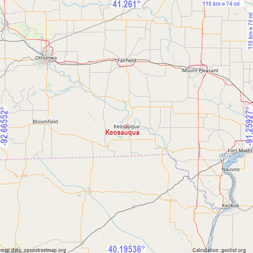
Keosauqua GPS coordinates[2]
40° 43' 49.116" North, 91° 57' 44.604" West
| Map corner | latitude | longitude |
|---|---|---|
| Upper-left | 41.261°, | -92.66552° |
| Center: | 40.73031°, | -91.96239° |
| Lower-right: | 40.19536°, | -91.25927° |
| Map W x H: | 118.5×118.5 km | = 73.6×73.6mi |
| max Lat: | 71.29058° ⇑38% North |
| Keosauqua: | 40.73031° |
| min Lat: | ⇓62% South 19.06759° |
| min Long | Keosauqua | max Long |
| -171.73463° | -91.96239° | -66.98998° |
| W 36%⇐ | ⇒64% E |
Elevation
Elevation of Keosauqua is 179 m = 587 ft, and this is 115.8 m = 380 ft below average elevation for this country.
| Max E: |
3189 m = 10463 ft | 55.3% |
| Avg. | 294.8 m = 967 ft | |
| Keosauqua | 179 m = 587 ft | |
Min E: |
-60 m = -197 ft | 44.7% |
See also: United States elevation on elevation.city.
Geographical zone
Keosauqua is located in North temperate zone (between Tropic of Cancer and the Arctic Circle). Distance of this Northern Tropic circle is 1922.9 km =1194.8 mi to South.| Distance of | km | miles | from Keosauqua |
|---|---|---|---|
| North Pole | 5478.3 | 3404.1 | to North |
| Arctic Circle | 2872.4 | 1784.8 | to North |
| Tropic Cancer | 1922.9 | 1194.8 | to South |
| Equator | 4528.8 | 2814.1 | to South |


Nearby cities:
15 places around Keosauqua: (largest is in red/bold)
• Agency
41.3 km =25.7 mi,  315°
315°
• Batavia
34 km =21.1 mi,  329°
329°
• Bloomfield
38.2 km =23.7 mi,  273°
273°
• Donnellson
34.9 km =21.7 mi,  106°
106°
• Eldon
30.3 km =18.8 mi,  313°
313°
• Fairfield
30.9 km =19.2 mi,  359°
359°
• Farmington
21 km =13 mi,  118°
118°
• Kahoka
40.1 km =24.9 mi,  149°
149°
• Maharishi Vedic City
35.9 km =22.3 mi, 355°
• Memphis
35.1 km =21.8 mi,  210°
210°
• Mount Pleasant
42.8 km =26.6 mi,  52°
52°
• Ottumwa
49.6 km =30.8 mi, 310°
• Richland
50.7 km =31.5 mi, 357°
• Wayland
49.2 km =30.6 mi,  139°
139°
• West Point
43.2 km =26.8 mi,  92°
92°
Sources, notices
• [Note1] Compared only with cities in United States existing in our database
• [Src1] Map data: © OpenStreetMap contributors (CC-BY-SA)
• [Src2] Other city data from geonames.org with taken over terms of usage.
• [Src3] Geographical zone / Annual Mean Temperature by Robert A. Rohde @ Wikipedia
