Eddyville geodata
Eddyville (Iowa) is a populated place; located in United States in America/Chicago (GMT-5) time zone. With population of 1,012 people, there are 16203 cities with bigger population in this country. Compared to other cities in United States, 67.4% of cities are located further ↓South; 65.5% of cities are located further →East and 51.5% of cities have lower elevation than Eddyville. Note1


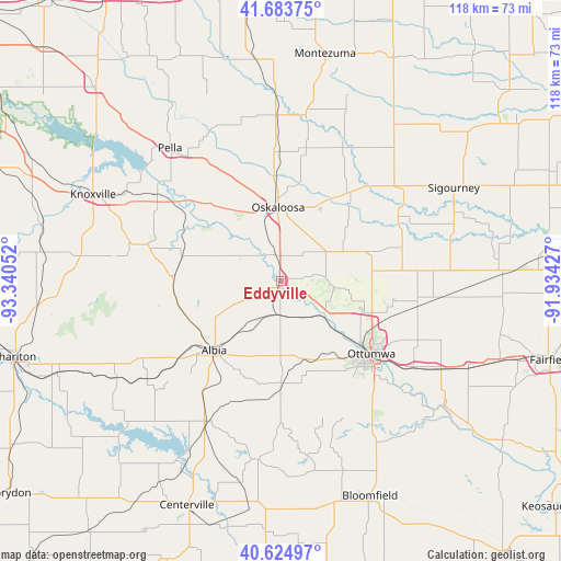
Eddyville GPS coordinates[2]
41° 9' 23.4" North, 92° 38' 14.604" West
| Map corner | latitude | longitude |
|---|---|---|
| Upper-left | 41.68375°, | -93.34052° |
| Center: | 41.1565°, | -92.63739° |
| Lower-right: | 40.62497°, | -91.93427° |
| Map W x H: | 117.7×117.7 km | = 73.1×73.1mi |
| max Lat: | 71.29058° ⇑32.6% North |
| Eddyville: | 41.1565° |
| min Lat: | ⇓67.4% South 19.06759° |
| min Long | Eddyville | max Long |
| -171.73463° | -92.63739° | -66.98998° |
| W 34.5%⇐ | ⇒65.5% E |
Elevation
Elevation of Eddyville is 204 m = 669 ft, and this is 90.8 m = 298 ft below average elevation for this country.
| Max E: |
3189 m = 10463 ft | 48.5% |
| Avg. | 294.8 m = 967 ft | |
| Eddyville | 204 m = 669 ft | |
Min E: |
-60 m = -197 ft | 51.5% |
See also: United States elevation on elevation.city.
Geographical zone
Eddyville is located in North temperate zone (between Tropic of Cancer and the Arctic Circle). Distance of this Northern Tropic circle is 1970.3 km =1224.3 mi to South.| Distance of | km | miles | from Eddyville |
|---|---|---|---|
| North Pole | 5430.9 | 3374.6 | to North |
| Arctic Circle | 2825 | 1755.4 | to North |
| Tropic Cancer | 1970.3 | 1224.3 | to South |
| Equator | 4576.2 | 2843.5 | to South |


Nearby cities:
15 places around Eddyville: (largest is in red/bold)
• Agency
33 km =20.5 mi,  122°
122°
• Albia
20.2 km =12.6 mi,  224°
224°
• Batavia
43.3 km =26.9 mi,  114°
114°
• Eldon
43.7 km =27.2 mi,  127°
127°
• Fremont
18 km =11.2 mi,  69°
69°
• Hedrick
27.6 km =17.1 mi,  86°
86°
• Knoxville
43.5 km =27 mi,  294°
294°
• Lovilia
22.4 km =13.9 mi,  264°
264°
• Moravia
33.1 km =20.6 mi,  206°
206°
• New Sharon
34.9 km =21.7 mi,  358°
358°
• Oskaloosa
15.6 km =9.7 mi, 357°
• Ottumwa
24.3 km =15.1 mi, 128°
• Pella
36.4 km =22.6 mi,  320°
320°
• Sigourney
41.2 km =25.6 mi,  61°
61°
• What Cheer
36.1 km =22.4 mi,  40°
40°
Sources, notices
• [Note1] Compared only with cities in United States existing in our database
• [Src1] Map data: © OpenStreetMap contributors (CC-BY-SA)
• [Src2] Other city data from geonames.org with taken over terms of usage.
• [Src3] Geographical zone / Annual Mean Temperature by Robert A. Rohde @ Wikipedia
