Hartford geodata
Hartford (Iowa) is a populated place; located in United States in America/Chicago (GMT-5) time zone. With population of 762 people, there are 18109 cities with bigger population in this country. Compared to other cities in United States, 70.4% of cities are located further ↓South; 67.3% of cities are located further →East and 65.6% of cities have lower elevation than Hartford. Note1


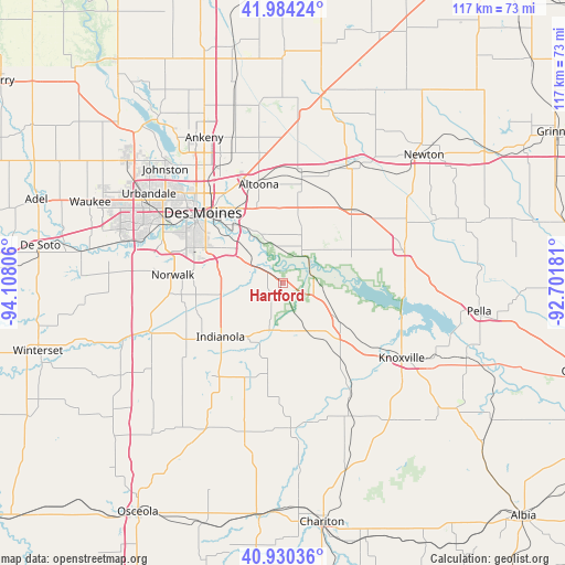
Hartford GPS coordinates[2]
41° 27' 33.984" North, 93° 24' 17.748" West
| Map corner | latitude | longitude |
|---|---|---|
| Upper-left | 41.98424°, | -94.10806° |
| Center: | 41.45944°, | -93.40493° |
| Lower-right: | 40.93036°, | -92.70181° |
| Map W x H: | 117.2×117.2 km | = 72.8×72.8mi |
| max Lat: | 71.29058° ⇑29.6% North |
| Hartford: | 41.45944° |
| min Lat: | ⇓70.4% South 19.06759° |
| min Long | Hartford | max Long |
| -171.73463° | -93.40493° | -66.98998° |
| W 32.7%⇐ | ⇒67.3% E |
Elevation
Elevation of Hartford is 265 m = 869 ft, and this is 29.8 m = 98 ft below average elevation for this country.
| Max E: |
3189 m = 10463 ft | 34.4% |
| Avg. | 294.8 m = 967 ft | |
| Hartford | 265 m = 869 ft | |
Min E: |
-60 m = -197 ft | 65.6% |
See also: United States elevation on elevation.city.
Geographical zone
Hartford is located in North temperate zone (between Tropic of Cancer and the Arctic Circle). Distance of this Northern Tropic circle is 2003.9 km =1245.2 mi to South.| Distance of | km | miles | from Hartford |
|---|---|---|---|
| North Pole | 5397.2 | 3353.7 | to North |
| Arctic Circle | 2791.3 | 1734.4 | to North |
| Tropic Cancer | 2003.9 | 1245.2 | to South |
| Equator | 4609.9 | 2864.5 | to South |


Nearby cities:
15 places around Hartford: (largest is in red/bold)
• Altoona
21.1 km =13.1 mi,  346°
346°
• Bondurant
27.2 km =16.9 mi, 349°
• Carlisle
8.5 km =5.3 mi,  302°
302°
• Colfax
27.7 km =17.2 mi,  28°
28°
• Des Moines
23.1 km =14.4 mi,  312°
312°
• Indianola
17 km =10.6 mi,  228°
228°
• Milo
18.9 km =11.7 mi,  189°
189°
• Mitchellville
23.6 km =14.7 mi,  9°
9°
• Monroe
26.2 km =16.3 mi,  74°
74°
• Norwalk
22.9 km =14.2 mi,  274°
274°
• Pleasant Hill
16.8 km =10.4 mi,  325°
325°
• Pleasantville
14 km =8.7 mi,  125°
125°
• Prairie City
21 km =13 mi,  42°
42°
• Runnells
7 km =4.3 mi, 34°
• West Des Moines
28.7 km =17.8 mi, 297°
Sources, notices
• [Note1] Compared only with cities in United States existing in our database
• [Src1] Map data: © OpenStreetMap contributors (CC-BY-SA)
• [Src2] Other city data from geonames.org with taken over terms of usage.
• [Src3] Geographical zone / Annual Mean Temperature by Robert A. Rohde @ Wikipedia
