Dunlap geodata
Dunlap (Iowa) is a populated place; located in United States in America/Chicago (GMT-5) time zone. With population of 977 people, there are 16437 cities with bigger population in this country. Compared to other cities in United States, 74.4% of cities are located further ↓South; 72.6% of cities are located further →East and 79.3% of cities have lower elevation than Dunlap. Note1


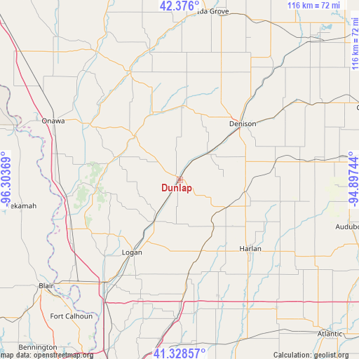
Dunlap GPS coordinates[2]
41° 51' 15.948" North, 95° 36' 2.016" West
| Map corner | latitude | longitude |
|---|---|---|
| Upper-left | 42.376°, | -96.30369° |
| Center: | 41.85443°, | -95.60056° |
| Lower-right: | 41.32857°, | -94.89744° |
| Map W x H: | 116.5×116.5 km | = 72.4×72.4mi |
| max Lat: | 71.29058° ⇑25.6% North |
| Dunlap: | 41.85443° |
| min Lat: | ⇓74.4% South 19.06759° |
| min Long | Dunlap | max Long |
| -171.73463° | -95.60056° | -66.98998° |
| W 27.4%⇐ | ⇒72.6% E |
Elevation
Elevation of Dunlap is 347 m = 1138 ft, and this is 52.2 m = 171 ft above average elevation for this country.
| Max E: |
3189 m = 10463 ft | 20.7% |
| Dunlap | 347 m 1138 ft | |
| Avg. | 294.8 m = 967 ft | |
Min E: |
-60 m = -197 ft | 79.3% |
See also: United States elevation on elevation.city.
Geographical zone
Dunlap is located in North temperate zone (between Tropic of Cancer and the Arctic Circle). Distance of this Northern Tropic circle is 2047.9 km =1272.5 mi to South.| Distance of | km | miles | from Dunlap |
|---|---|---|---|
| North Pole | 5353.3 | 3326.4 | to North |
| Arctic Circle | 2747.4 | 1707.2 | to North |
| Tropic Cancer | 2047.9 | 1272.5 | to South |
| Equator | 4653.8 | 2891.7 | to South |


Nearby cities:
15 places around Dunlap: (largest is in red/bold)
• Avoca
47.3 km =29.4 mi,  152°
152°
• Battle Creek
51.3 km =31.9 mi,  0°
0°
• Denison
27.2 km =16.9 mi,  48°
48°
• Harlan
32 km =19.9 mi,  134°
134°
• Logan
28.2 km =17.5 mi,  213°
213°
• Manilla
30.7 km =19.1 mi,  82°
82°
• Manning
44.8 km =27.8 mi, 82°
• Mapleton
38.1 km =23.7 mi,  335°
335°
• Minden
43.4 km =27 mi,  173°
173°
• Missouri Valley
40.8 km =25.4 mi,  215°
215°
• Neola
45.1 km =28 mi,  181°
181°
• Onawa
45.3 km =28.1 mi,  294°
294°
• Schleswig
37.1 km =23.1 mi,  21°
21°
• Shelby
39.6 km =24.6 mi,  161°
161°
• Woodbine
15.4 km =9.6 mi, 213°
Sources, notices
• [Note1] Compared only with cities in United States existing in our database
• [Src1] Map data: © OpenStreetMap contributors (CC-BY-SA)
• [Src2] Other city data from geonames.org with taken over terms of usage.
• [Src3] Geographical zone / Annual Mean Temperature by Robert A. Rohde @ Wikipedia
