Raymond geodata
Raymond (Iowa) is a populated place; located in United States in America/Chicago (GMT-5) time zone. With population of 816 people, there are 17663 cities with bigger population in this country. Compared to other cities in United States, 79.5% of cities are located further ↓South; 64.6% of cities are located further →East and 68.9% of cities have lower elevation than Raymond. Note1


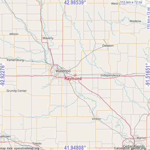
Raymond GPS coordinates[2]
42° 28' 7.968" North, 92° 13' 10.668" West
| Map corner | latitude | longitude |
|---|---|---|
| Upper-left | 42.98539°, | -92.92276° |
| Center: | 42.46888°, | -92.21963° |
| Lower-right: | 41.94808°, | -91.51651° |
| Map W x H: | 115.3×115.3 km | = 71.6×71.6mi |
| max Lat: | 71.29058° ⇑20.5% North |
| Raymond: | 42.46888° |
| min Lat: | ⇓79.5% South 19.06759° |
| min Long | Raymond | max Long |
| -171.73463° | -92.21963° | -66.98998° |
| W 35.4%⇐ | ⇒64.6% E |
Elevation
Elevation of Raymond is 280 m = 919 ft, and this is 14.8 m = 49 ft below average elevation for this country.
| Max E: |
3189 m = 10463 ft | 31.1% |
| Avg. | 294.8 m = 967 ft | |
| Raymond | 280 m = 919 ft | |
Min E: |
-60 m = -197 ft | 68.9% |
See also: United States elevation on elevation.city.
Geographical zone
Raymond is located in North temperate zone (between Tropic of Cancer and the Arctic Circle). Distance of this Northern Tropic circle is 2116.2 km =1314.9 mi to South.| Distance of | km | miles | from Raymond |
|---|---|---|---|
| North Pole | 5285 | 3283.9 | to North |
| Arctic Circle | 2679.1 | 1664.7 | to North |
| Tropic Cancer | 2116.2 | 1314.9 | to South |
| Equator | 4722.1 | 2934.2 | to South |


Nearby cities:
15 places around Raymond: (largest is in red/bold)
• Cedar Falls
19.6 km =12.2 mi,  289°
289°
• Denver
24.5 km =15.2 mi,  336°
336°
• Dunkerton
12.2 km =7.6 mi,  23°
23°
• Elk Run Heights
3 km =1.9 mi,  265°
265°
• Evansdale
5 km =3.1 mi, 270°
• Fairbank
23.6 km =14.7 mi,  36°
36°
• Gilbertville
5.9 km =3.7 mi,  176°
176°
• Hudson
20.6 km =12.8 mi,  250°
250°
• Independence
27.1 km =16.8 mi,  90°
90°
• Janesville
28 km =17.4 mi,  314°
314°
• Jesup
12.8 km =8 mi, 86°
• La Porte City
17.3 km =10.7 mi,  172°
172°
• Readlyn
25.9 km =16.1 mi,  358°
358°
• Washburn
7.5 km =4.7 mi,  211°
211°
• Waterloo
10.5 km =6.5 mi,  284°
284°
Sources, notices
• [Note1] Compared only with cities in United States existing in our database
• [Src1] Map data: © OpenStreetMap contributors (CC-BY-SA)
• [Src2] Other city data from geonames.org with taken over terms of usage.
• [Src3] Geographical zone / Annual Mean Temperature by Robert A. Rohde @ Wikipedia
