Readlyn geodata
Readlyn (Iowa) is a populated place; located in United States in America/Chicago (GMT-5) time zone. With population of 826 people, there are 17560 cities with bigger population in this country. Compared to other cities in United States, 81.3% of cities are located further ↓South; 64.7% of cities are located further →East and 75.4% of cities have lower elevation than Readlyn. Note1


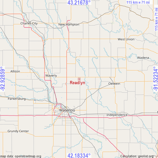
Readlyn GPS coordinates[2]
42° 42' 7.956" North, 92° 13' 31.656" West
| Map corner | latitude | longitude |
|---|---|---|
| Upper-left | 43.21678°, | -92.92859° |
| Center: | 42.70221°, | -92.22546° |
| Lower-right: | 42.18334°, | -91.52234° |
| Map W x H: | 114.9×114.9 km | = 71.4×71.4mi |
| max Lat: | 71.29058° ⇑18.7% North |
| Readlyn: | 42.70221° |
| min Lat: | ⇓81.3% South 19.06759° |
| min Long | Readlyn | max Long |
| -171.73463° | -92.22546° | -66.98998° |
| W 35.3%⇐ | ⇒64.7% E |
Elevation
Elevation of Readlyn is 316 m = 1037 ft, and this is 21.2 m = 70 ft above average elevation for this country.
| Max E: |
3189 m = 10463 ft | 24.6% |
| Readlyn | 316 m 1037 ft | |
| Avg. | 294.8 m = 967 ft | |
Min E: |
-60 m = -197 ft | 75.4% |
See also: United States elevation on elevation.city.
Geographical zone
Readlyn is located in North temperate zone (between Tropic of Cancer and the Arctic Circle). Distance of this Northern Tropic circle is 2142.1 km =1331 mi to South.| Distance of | km | miles | from Readlyn |
|---|---|---|---|
| North Pole | 5259 | 3267.8 | to North |
| Arctic Circle | 2653.1 | 1648.6 | to North |
| Tropic Cancer | 2142.1 | 1331 | to South |
| Equator | 4748 | 2950.3 | to South |


Nearby cities:
15 places around Readlyn: (largest is in red/bold)
• Cedar Falls
26.5 km =16.5 mi,  222°
222°
• Denver
9.8 km =6.1 mi,  249°
249°
• Dunkerton
15.6 km =9.7 mi,  160°
160°
• Elk Run Heights
26.3 km =16.3 mi,  185°
185°
• Evansdale
26.3 km =16.3 mi, 189°
• Fairbank
16.2 km =10.1 mi,  115°
115°
• Hazleton
28.1 km =17.5 mi,  108°
108°
• Janesville
20.4 km =12.7 mi, 252°
• Jesup
28.5 km =17.7 mi,  152°
152°
• Oelwein
25.7 km =16 mi,  97°
97°
• Raymond
25.9 km =16.1 mi,  178°
178°
• Sumner
19.5 km =12.1 mi,  34°
34°
• Tripoli
12.1 km =7.5 mi,  347°
347°
• Waterloo
25.2 km =15.7 mi,  202°
202°
• Waverly
20.6 km =12.8 mi,  277°
277°
Sources, notices
• [Note1] Compared only with cities in United States existing in our database
• [Src1] Map data: © OpenStreetMap contributors (CC-BY-SA)
• [Src2] Other city data from geonames.org with taken over terms of usage.
• [Src3] Geographical zone / Annual Mean Temperature by Robert A. Rohde @ Wikipedia
