Oelwein geodata
Oelwein (Iowa) is a populated place; located in United States in America/Chicago (GMT-5) time zone. With population of 6,153 people, there are 6302 cities with bigger population in this country. Compared to other cities in United States, 81.1% of cities are located further ↓South; 63.9% of cities are located further →East and 75.5% of cities have lower elevation than Oelwein. Note1


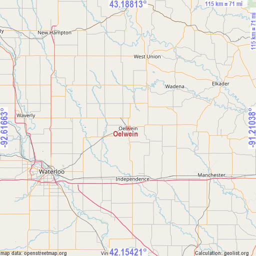
Oelwein GPS coordinates[2]
42° 40' 23.952" North, 91° 54' 48.6" West
| Map corner | latitude | longitude |
|---|---|---|
| Upper-left | 43.18813°, | -92.61663° |
| Center: | 42.67332°, | -91.9135° |
| Lower-right: | 42.15421°, | -91.21038° |
| Map W x H: | 115×115 km | = 71.5×71.5mi |
| max Lat: | 71.29058° ⇑18.9% North |
| Oelwein: | 42.67332° |
| min Lat: | ⇓81.1% South 19.06759° |
| min Long | Oelwein | max Long |
| -171.73463° | -91.9135° | -66.98998° |
| W 36.1%⇐ | ⇒63.9% E |
Elevation
Elevation of Oelwein is 317 m = 1040 ft, and this is 22.2 m = 73 ft above average elevation for this country.
| Max E: |
3189 m = 10463 ft | 24.5% |
| Oelwein | 317 m 1040 ft | |
| Avg. | 294.8 m = 967 ft | |
Min E: |
-60 m = -197 ft | 75.5% |
See also: United States elevation on elevation.city.
Geographical zone
Oelwein is located in North temperate zone (between Tropic of Cancer and the Arctic Circle). Distance of this Northern Tropic circle is 2138.9 km =1329.1 mi to South.| Distance of | km | miles | from Oelwein |
|---|---|---|---|
| North Pole | 5262.2 | 3269.8 | to North |
| Arctic Circle | 2656.3 | 1650.5 | to North |
| Tropic Cancer | 2138.9 | 1329.1 | to South |
| Equator | 4744.8 | 2948.3 | to South |


Nearby cities:
15 places around Oelwein: (largest is in red/bold)
• Denver
34.7 km =21.6 mi,  269°
269°
• Dunkerton
23.2 km =14.4 mi,  240°
240°
• Fairbank
11.6 km =7.2 mi,  250°
250°
• Fayette
20.8 km =12.9 mi,  25°
25°
• Hazleton
5.9 km =3.7 mi,  169°
169°
• Independence
22.8 km =14.2 mi,  175°
175°
• Jesup
25.2 km =15.7 mi,  209°
209°
• Quasqueton
33.4 km =20.8 mi,  158°
158°
• Raymond
33.8 km =21 mi,  227°
227°
• Readlyn
25.7 km =16 mi,  277°
277°
• Strawberry Point
31 km =19.3 mi,  87°
87°
• Sumner
24.2 km =15 mi,  323°
323°
• Tripoli
31.9 km =19.8 mi,  298°
298°
• West Union
33.3 km =20.7 mi,  14°
14°
• Winthrop
26.6 km =16.5 mi,  146°
146°
Sources, notices
• [Note1] Compared only with cities in United States existing in our database
• [Src1] Map data: © OpenStreetMap contributors (CC-BY-SA)
• [Src2] Other city data from geonames.org with taken over terms of usage.
• [Src3] Geographical zone / Annual Mean Temperature by Robert A. Rohde @ Wikipedia
