Nevada geodata
Nevada (Iowa) is a seat of a second-order administrative division; located in United States in America/Chicago (GMT-5) time zone. With population of 6,831 people, there are 5905 cities with bigger population in this country. Compared to other cities in United States, 75.9% of cities are located further ↓South; 67.4% of cities are located further →East and 74% of cities have lower elevation than Nevada. Note1


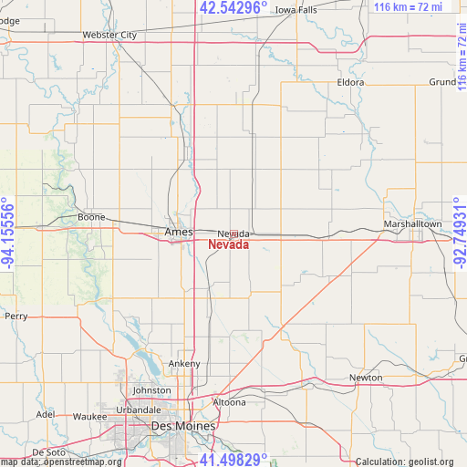
Nevada GPS coordinates[2]
42° 1' 21.972" North, 93° 27' 8.748" West
| Map corner | latitude | longitude |
|---|---|---|
| Upper-left | 42.54296°, | -94.15556° |
| Center: | 42.02277°, | -93.45243° |
| Lower-right: | 41.49829°, | -92.74931° |
| Map W x H: | 116.2×116.2 km | = 72.2×72.2mi |
| max Lat: | 71.29058° ⇑24.1% North |
| Nevada: | 42.02277° |
| min Lat: | ⇓75.9% South 19.06759° |
| min Long | Nevada | max Long |
| -171.73463° | -93.45243° | -66.98998° |
| W 32.6%⇐ | ⇒67.4% E |
Elevation
Elevation of Nevada is 307 m = 1007 ft, and this is 12.2 m = 40 ft above average elevation for this country.
| Max E: |
3189 m = 10463 ft | 26% |
| Nevada | 307 m 1007 ft | |
| Avg. | 294.8 m = 967 ft | |
Min E: |
-60 m = -197 ft | 74% |
See also: United States elevation on elevation.city.
Geographical zone
Nevada is located in North temperate zone (between Tropic of Cancer and the Arctic Circle). Distance of this Northern Tropic circle is 2066.6 km =1284.1 mi to South.| Distance of | km | miles | from Nevada |
|---|---|---|---|
| North Pole | 5334.6 | 3314.8 | to North |
| Arctic Circle | 2728.7 | 1695.5 | to North |
| Tropic Cancer | 2066.6 | 1284.1 | to South |
| Equator | 4672.5 | 2903.4 | to South |


Nearby cities:
15 places around Nevada: (largest is in red/bold)
• Ames
13.9 km =8.6 mi,  275°
275°
• Baxter
33.1 km =20.6 mi,  131°
131°
• Cambridge
15.2 km =9.4 mi,  204°
204°
• Colo
11.3 km =7 mi,  92°
92°
• Elkhart
26.3 km =16.3 mi,  192°
192°
• Gilbert
18.8 km =11.7 mi,  299°
299°
• Huxley
18.7 km =11.6 mi,  220°
220°
• Maxwell
15.2 km =9.4 mi,  163°
163°
• Melbourne
30.2 km =18.8 mi,  107°
107°
• Radcliffe
32.6 km =20.3 mi,  2°
2°
• Roland
16.5 km =10.3 mi,  345°
345°
• Slater
24.7 km =15.3 mi,  229°
229°
• State Center
23.9 km =14.9 mi, 91°
• Story City
21.8 km =13.5 mi,  327°
327°
• Zearing
20 km =12.4 mi,  39°
39°
Sources, notices
• [Note1] Compared only with cities in United States existing in our database
• [Src1] Map data: © OpenStreetMap contributors (CC-BY-SA)
• [Src2] Other city data from geonames.org with taken over terms of usage.
• [Src3] Geographical zone / Annual Mean Temperature by Robert A. Rohde @ Wikipedia
