Ames geodata
Ames (Iowa) is a populated place; located in United States in America/Chicago (GMT-5) time zone. With population of 65,060 people, there are 660 cities with bigger population in this country. Compared to other cities in United States, 76% of cities are located further ↓South; 67.8% of cities are located further →East and 71.3% of cities have lower elevation than Ames. Note1


Ames GPS coordinates[2]
42° 2' 4.956" North, 93° 37' 11.784" West
| Map corner | latitude | longitude |
|---|---|---|
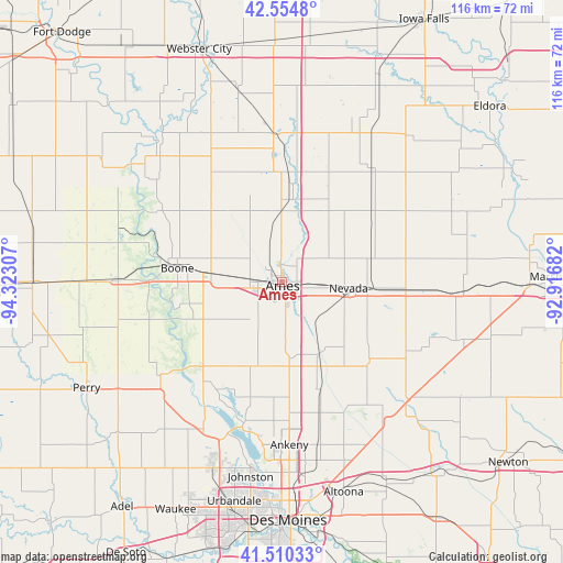
| Upper-left | 42.5548°, | -94.32307° |
| Center: | 42.03471°, | -93.61994° |
| Lower-right: | 41.51033°, | -92.91682° |
| Map W x H: | 116.1×116.1 km | = 72.1×72.1mi |
| max Lat: | 71.29058° ⇑24% North |
| Ames: | 42.03471° |
| min Lat: | ⇓76% South 19.06759° |
| min Long | Ames | max Long |
| -171.73463° | -93.61994° | -66.98998° |
| W 32.2%⇐ | ⇒67.8% E |
Elevation
Elevation of Ames is 292 m = 958 ft, and this is 2.8 m = 9 ft below average elevation for this country.
| Max E: |
3189 m = 10463 ft | 28.7% |
| Avg. | 294.8 m = 967 ft | |
| Ames | 292 m = 958 ft | |
Min E: |
-60 m = -197 ft | 71.3% |
See also: Ames elevation on elevation.city.
Geographical zone
Ames is located in North temperate zone (between Tropic of Cancer and the Arctic Circle). Distance of this Northern Tropic circle is 2067.9 km =1284.9 mi to South.| Distance of | km | miles | from Ames |
|---|---|---|---|
| North Pole | 5333.2 | 3313.9 | to North |
| Arctic Circle | 2727.4 | 1694.7 | to North |
| Tropic Cancer | 2067.9 | 1284.9 | to South |
| Equator | 4673.8 | 2904.2 | to South |


Nearby cities:
15 places around Ames: (largest is in red/bold)
• Boone
21.7 km =13.5 mi,  277°
277°
• Cambridge
16.9 km =10.5 mi,  153°
153°
• Centerville
26.8 km =16.7 mi, 283°
• Colo
25.2 km =15.7 mi,  94°
94°
• Elkhart
28.2 km =17.5 mi,  163°
163°
• Gilbert
8.4 km =5.2 mi,  343°
343°
• Huxley
15.6 km =9.7 mi,  174°
174°
• Madrid
24.3 km =15.1 mi,  223°
223°
• Maxwell
24.2 km =15 mi,  131°
131°
• Nevada
13.9 km =8.6 mi,  95°
95°
• Polk City
30.3 km =18.8 mi,  194°
194°
• Roland
17.6 km =10.9 mi,  33°
33°
• Slater
18.1 km =11.2 mi,  195°
195°
• Story City
17.1 km =10.6 mi,  6°
6°
• Zearing
30.1 km =18.7 mi,  62°
62°
Sources, notices
• [Note1] Compared only with cities in United States existing in our database
• [Src1] Map data: © OpenStreetMap contributors (CC-BY-SA)
• [Src2] Other city data from geonames.org with taken over terms of usage.
• [Src3] Geographical zone / Annual Mean Temperature by Robert A. Rohde @ Wikipedia
