Stratford geodata
Stratford (Iowa) is a populated place; located in United States in America/Chicago (GMT-5) time zone. With population of 725 people, there are 18450 cities with bigger population in this country. Compared to other cities in United States, 78% of cities are located further ↓South; 68.5% of cities are located further →East and 78.6% of cities have lower elevation than Stratford. Note1


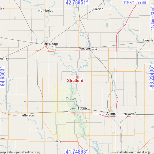
Stratford GPS coordinates[2]
42° 16' 16.932" North, 93° 55' 37.812" West
| Map corner | latitude | longitude |
|---|---|---|
| Upper-left | 42.78951°, | -94.6303° |
| Center: | 42.27137°, | -93.92717° |
| Lower-right: | 41.74893°, | -93.22405° |
| Map W x H: | 115.7×115.7 km | = 71.9×71.9mi |
| max Lat: | 71.29058° ⇑22% North |
| Stratford: | 42.27137° |
| min Lat: | ⇓78% South 19.06759° |
| min Long | Stratford | max Long |
| -171.73463° | -93.92717° | -66.98998° |
| W 31.5%⇐ | ⇒68.5% E |
Elevation
Elevation of Stratford is 341 m = 1119 ft, and this is 46.2 m = 152 ft above average elevation for this country.
| Max E: |
3189 m = 10463 ft | 21.4% |
| Stratford | 341 m 1119 ft | |
| Avg. | 294.8 m = 967 ft | |
Min E: |
-60 m = -197 ft | 78.6% |
See also: United States elevation on elevation.city.
Geographical zone
Stratford is located in North temperate zone (between Tropic of Cancer and the Arctic Circle). Distance of this Northern Tropic circle is 2094.2 km =1301.3 mi to South.| Distance of | km | miles | from Stratford |
|---|---|---|---|
| North Pole | 5306.9 | 3297.6 | to North |
| Arctic Circle | 2701 | 1678.3 | to North |
| Tropic Cancer | 2094.2 | 1301.3 | to South |
| Equator | 4700.1 | 2920.5 | to South |


Nearby cities:
15 places around Stratford: (largest is in red/bold)
• Ames
36.5 km =22.7 mi,  136°
136°
• Boone
23.9 km =14.9 mi,  170°
170°
• Centerville
19.9 km =12.4 mi,  181°
181°
• Coalville
25.3 km =15.7 mi,  319°
319°
• Dayton
11.7 km =7.3 mi,  264°
264°
• Ellsworth
29 km =18 mi,  80°
80°
• Fort Dodge
32 km =19.9 mi, 321°
• Gilbert
29.3 km =18.2 mi,  128°
128°
• Gowrie
29.9 km =18.6 mi,  271°
271°
• Jewell
23.9 km =14.9 mi, 80°
• Ogden
27.1 km =16.8 mi,  197°
197°
• Otho
25 km =15.5 mi,  312°
312°
• Roland
36.9 km =22.9 mi,  108°
108°
• Story City
28.8 km =17.9 mi, 108°
• Webster City
23.8 km =14.8 mi,  22°
22°
Sources, notices
• [Note1] Compared only with cities in United States existing in our database
• [Src1] Map data: © OpenStreetMap contributors (CC-BY-SA)
• [Src2] Other city data from geonames.org with taken over terms of usage.
• [Src3] Geographical zone / Annual Mean Temperature by Robert A. Rohde @ Wikipedia
