Boone geodata
Boone (Iowa) is a seat of a second-order administrative division; located in United States in America/Chicago (GMT-5) time zone. With population of 12,692 people, there are 3730 cities with bigger population in this country. Compared to other cities in United States, 76.2% of cities are located further ↓South; 68.4% of cities are located further →East and 78.8% of cities have lower elevation than Boone. Note1


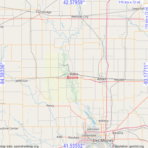
Boone GPS coordinates[2]
42° 3' 34.92" North, 93° 52' 48.828" West
| Map corner | latitude | longitude |
|---|---|---|
| Upper-left | 42.57959°, | -94.58336° |
| Center: | 42.0597°, | -93.88023° |
| Lower-right: | 41.53552°, | -93.17711° |
| Map W x H: | 116.1×116.1 km | = 72.1×72.1mi |
| max Lat: | 71.29058° ⇑23.8% North |
| Boone: | 42.0597° |
| min Lat: | ⇓76.2% South 19.06759° |
| min Long | Boone | max Long |
| -171.73463° | -93.88023° | -66.98998° |
| W 31.6%⇐ | ⇒68.4% E |
Elevation
Elevation of Boone is 343 m = 1125 ft, and this is 48.2 m = 158 ft above average elevation for this country.
| Max E: |
3189 m = 10463 ft | 21.2% |
| Boone | 343 m 1125 ft | |
| Avg. | 294.8 m = 967 ft | |
Min E: |
-60 m = -197 ft | 78.8% |
See also: United States elevation on elevation.city.
Geographical zone
Boone is located in North temperate zone (between Tropic of Cancer and the Arctic Circle). Distance of this Northern Tropic circle is 2070.7 km =1286.7 mi to South.| Distance of | km | miles | from Boone |
|---|---|---|---|
| North Pole | 5330.5 | 3312.2 | to North |
| Arctic Circle | 2724.6 | 1693 | to North |
| Tropic Cancer | 2070.7 | 1286.7 | to South |
| Equator | 4676.6 | 2905.9 | to South |


Nearby cities:
15 places around Boone: (largest is in red/bold)
• Ames
21.7 km =13.5 mi,  97°
97°
• Centerville
5.9 km =3.7 mi,  308°
308°
• Dayton
27.3 km =17 mi,  325°
325°
• Gilbert
19.7 km =12.2 mi,  74°
74°
• Grand Junction
29.9 km =18.6 mi,  264°
264°
• Granger
33.5 km =20.8 mi,  172°
172°
• Huxley
29.5 km =18.3 mi,  128°
128°
• Madrid
20.9 km =13 mi, 166°
• Ogden
12.4 km =7.7 mi, 259°
• Perry
30.9 km =19.2 mi,  217°
217°
• Roland
33.4 km =20.8 mi, 69°
• Slater
26.2 km =16.3 mi,  140°
140°
• Story City
27.4 km =17 mi,  58°
58°
• Stratford
23.9 km =14.9 mi,  350°
350°
• Woodward
22.8 km =14.2 mi,  188°
188°
Sources, notices
• [Note1] Compared only with cities in United States existing in our database
• [Src1] Map data: © OpenStreetMap contributors (CC-BY-SA)
• [Src2] Other city data from geonames.org with taken over terms of usage.
• [Src3] Geographical zone / Annual Mean Temperature by Robert A. Rohde @ Wikipedia
