Elburn geodata
Elburn (Illinois) is a populated place; located in United States in America/Chicago (GMT-5) time zone. With population of 5,748 people, there are 6574 cities with bigger population in this country. Compared to other cities in United States, 74.7% of cities are located further ↓South; 54.7% of cities are located further →East and 64.8% of cities have lower elevation than Elburn. Note1


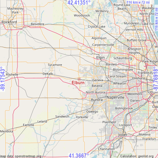
Elburn GPS coordinates[2]
41° 53' 32.1" North, 88° 28' 20.28" West
| Map corner | latitude | longitude |
|---|---|---|
| Upper-left | 42.41351°, | -89.17543° |
| Center: | 41.89225°, | -88.4723° |
| Lower-right: | 41.3667°, | -87.76918° |
| Map W x H: | 116.4×116.4 km | = 72.3×72.3mi |
| max Lat: | 71.29058° ⇑25.3% North |
| Elburn: | 41.89225° |
| min Lat: | ⇓74.7% South 19.06759° |
| min Long | Elburn | max Long |
| -171.73463° | -88.4723° | -66.98998° |
| W 45.3%⇐ | ⇒54.7% E |
Elevation
Elevation of Elburn is 261 m = 856 ft, and this is 33.8 m = 111 ft below average elevation for this country.
| Max E: |
3189 m = 10463 ft | 35.2% |
| Avg. | 294.8 m = 967 ft | |
| Elburn | 261 m = 856 ft | |
Min E: |
-60 m = -197 ft | 64.8% |
See also: United States elevation on elevation.city.
Geographical zone
Elburn is located in North temperate zone (between Tropic of Cancer and the Arctic Circle). Distance of this Northern Tropic circle is 2052.1 km =1275.1 mi to South.| Distance of | km | miles | from Elburn |
|---|---|---|---|
| North Pole | 5349.1 | 3323.8 | to North |
| Arctic Circle | 2743.2 | 1704.5 | to North |
| Tropic Cancer | 2052.1 | 1275.1 | to South |
| Equator | 4658 | 2894.3 | to South |


Nearby cities:
15 places around Elburn: (largest is in red/bold)
• Batavia
14 km =8.7 mi,  109°
109°
• Big Rock
15.6 km =9.7 mi,  203°
203°
• Burlington
18.9 km =11.7 mi,  340°
340°
• Cortland
18.2 km =11.3 mi,  279°
279°
• Farmington
14.2 km =8.8 mi,  65°
65°
• Geneva
13.8 km =8.6 mi,  92°
92°
• Lily Lake
6.3 km =3.9 mi,  355°
355°
• Maple Park
10.6 km =6.6 mi, 279°
• North Aurora
15.4 km =9.6 mi,  128°
128°
• Prestbury
12.9 km =8 mi,  159°
159°
• Saint Charles
13.8 km =8.6 mi,  79°
79°
• South Elgin
18.7 km =11.6 mi,  52°
52°
• Sugar Grove
14.7 km =9.1 mi,  170°
170°
• Village of Campton Hills
7.9 km =4.9 mi, 51°
• Wasco
7.6 km =4.7 mi, 47°
Sources, notices
• [Note1] Compared only with cities in United States existing in our database
• [Src1] Map data: © OpenStreetMap contributors (CC-BY-SA)
• [Src2] Other city data from geonames.org with taken over terms of usage.
• [Src3] Geographical zone / Annual Mean Temperature by Robert A. Rohde @ Wikipedia
