North Aurora geodata
North Aurora (Illinois) is a populated place; located in United States in America/Chicago (GMT-5) time zone. With population of 17,456 people, there are 2851 cities with bigger population in this country. Compared to other cities in United States, 74% of cities are located further ↓South; 54.2% of cities are located further →East and 53% of cities have lower elevation than North Aurora. Note1


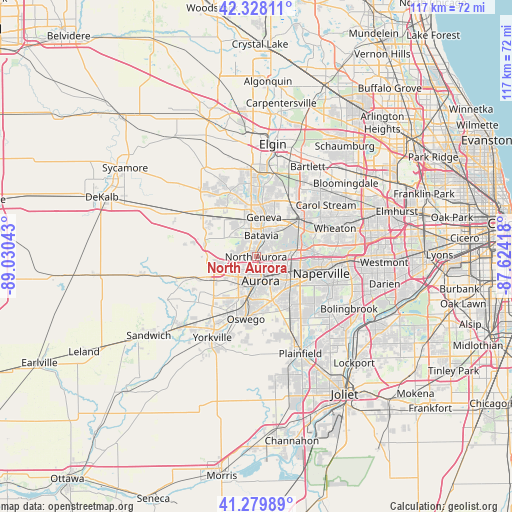
North Aurora GPS coordinates[2]
41° 48' 22.104" North, 88° 19' 38.28" West
| Map corner | latitude | longitude |
|---|---|---|
| Upper-left | 42.32811°, | -89.03043° |
| Center: | 41.80614°, | -88.3273° |
| Lower-right: | 41.27989°, | -87.62418° |
| Map W x H: | 116.6×116.6 km | = 72.5×72.5mi |
| max Lat: | 71.29058° ⇑26% North |
| North Aurora: | 41.80614° |
| min Lat: | ⇓74% South 19.06759° |
| min Long | North Aurora | max Long |
| -171.73463° | -88.3273° | -66.98998° |
| W 45.8%⇐ | ⇒54.2% E |
Elevation
Elevation of North Aurora is 210 m = 689 ft, and this is 84.8 m = 278 ft below average elevation for this country.
| Max E: |
3189 m = 10463 ft | 47% |
| Avg. | 294.8 m = 967 ft | |
| North Aurora | 210 m = 689 ft | |
Min E: |
-60 m = -197 ft | 53% |
See also: United States elevation on elevation.city.
Geographical zone
North Aurora is located in North temperate zone (between Tropic of Cancer and the Arctic Circle). Distance of this Northern Tropic circle is 2042.5 km =1269.2 mi to South.| Distance of | km | miles | from North Aurora |
|---|---|---|---|
| North Pole | 5358.7 | 3329.7 | to North |
| Arctic Circle | 2752.8 | 1710.5 | to North |
| Tropic Cancer | 2042.5 | 1269.2 | to South |
| Equator | 4648.4 | 2888.4 | to South |


Nearby cities:
15 places around North Aurora: (largest is in red/bold)
• Aurora
5.1 km =3.2 mi,  173°
173°
• Batavia
5 km =3.1 mi,  14°
14°
• Boulder Hill
10.4 km =6.5 mi,  184°
184°
• Farmington
15.4 km =9.6 mi,  3°
3°
• Geneva
9.2 km =5.7 mi, 11°
• Lynwood
14.7 km =9.1 mi,  202°
202°
• Montgomery
8.5 km =5.3 mi,  190°
190°
• Naperville
15.1 km =9.4 mi,  98°
98°
• Oswego
13.9 km =8.6 mi, 188°
• Prestbury
7.9 km =4.9 mi,  251°
251°
• Saint Charles
12.1 km =7.5 mi, 7°
• Sugar Grove
10.9 km =6.8 mi,  242°
242°
• Warrenville
12.8 km =8 mi,  84°
84°
• West Chicago
13.4 km =8.3 mi,  49°
49°
• Winfield
15.1 km =9.4 mi,  65°
65°
Sources, notices
• [Note1] Compared only with cities in United States existing in our database
• [Src1] Map data: © OpenStreetMap contributors (CC-BY-SA)
• [Src2] Other city data from geonames.org with taken over terms of usage.
• [Src3] Geographical zone / Annual Mean Temperature by Robert A. Rohde @ Wikipedia
