Sugar Grove geodata
Sugar Grove (Illinois) is a populated place; located in United States in America/Chicago (GMT-5) time zone. With population of 9,512 people, there are 4618 cities with bigger population in this country. Compared to other cities in United States, 73.5% of cities are located further ↓South; 54.6% of cities are located further →East and 55.4% of cities have lower elevation than Sugar Grove. Note1


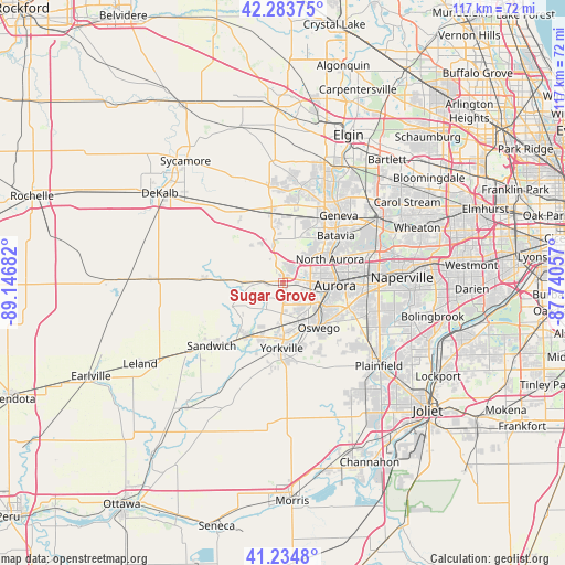
Sugar Grove GPS coordinates[2]
41° 45' 41.112" North, 88° 26' 37.284" West
| Map corner | latitude | longitude |
|---|---|---|
| Upper-left | 42.28375°, | -89.14682° |
| Center: | 41.76142°, | -88.44369° |
| Lower-right: | 41.2348°, | -87.74057° |
| Map W x H: | 116.6×116.6 km | = 72.5×72.5mi |
| max Lat: | 71.29058° ⇑26.5% North |
| Sugar Grove: | 41.76142° |
| min Lat: | ⇓73.5% South 19.06759° |
| min Long | Sugar Grove | max Long |
| -171.73463° | -88.44369° | -66.98998° |
| W 45.4%⇐ | ⇒54.6% E |
Elevation
Elevation of Sugar Grove is 220 m = 722 ft, and this is 74.8 m = 245 ft below average elevation for this country.
| Max E: |
3189 m = 10463 ft | 44.6% |
| Avg. | 294.8 m = 967 ft | |
| Sugar Grove | 220 m = 722 ft | |
Min E: |
-60 m = -197 ft | 55.4% |
See also: United States elevation on elevation.city.
Geographical zone
Sugar Grove is located in North temperate zone (between Tropic of Cancer and the Arctic Circle). Distance of this Northern Tropic circle is 2037.5 km =1266 mi to South.| Distance of | km | miles | from Sugar Grove |
|---|---|---|---|
| North Pole | 5363.6 | 3332.8 | to North |
| Arctic Circle | 2757.7 | 1713.6 | to North |
| Tropic Cancer | 2037.5 | 1266 | to South |
| Equator | 4643.4 | 2885.3 | to South |


Nearby cities:
15 places around Sugar Grove: (largest is in red/bold)
• Aurora
10.3 km =6.4 mi,  90°
90°
• Batavia
14.7 km =9.1 mi,  47°
47°
• Big Rock
8.6 km =5.3 mi,  271°
271°
• Boulder Hill
10.4 km =6.5 mi,  121°
121°
• Elburn
14.7 km =9.1 mi,  350°
350°
• Geneva
18.1 km =11.2 mi,  39°
39°
• Hinckley
16.4 km =10.2 mi, 272°
• Lynwood
9.6 km =6 mi,  154°
154°
• Montgomery
8.8 km =5.5 mi,  112°
112°
• North Aurora
10.9 km =6.8 mi,  62°
62°
• Oswego
11.6 km =7.2 mi,  138°
138°
• Plano
13.4 km =8.3 mi,  215°
215°
• Prestbury
3.3 km =2.1 mi, 41°
• Sandwich
19.6 km =12.2 mi,  228°
228°
• Yorkville
13.4 km =8.3 mi,  181°
181°
Sources, notices
• [Note1] Compared only with cities in United States existing in our database
• [Src1] Map data: © OpenStreetMap contributors (CC-BY-SA)
• [Src2] Other city data from geonames.org with taken over terms of usage.
• [Src3] Geographical zone / Annual Mean Temperature by Robert A. Rohde @ Wikipedia
