Heyworth geodata
Heyworth (Illinois) is a populated place; located in United States in America/Chicago (GMT-5) time zone. With population of 2,890 people, there are 9824 cities with bigger population in this country. Compared to other cities in United States, 56.8% of cities are located further ↓South; 56% of cities are located further →East and 58.6% of cities have lower elevation than Heyworth. Note1


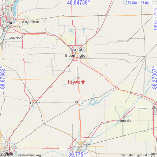
Heyworth GPS coordinates[2]
40° 18' 48.132" North, 88° 58' 25.284" West
| Map corner | latitude | longitude |
|---|---|---|
| Upper-left | 40.84738°, | -89.67682° |
| Center: | 40.31337°, | -88.97369° |
| Lower-right: | 39.7751°, | -88.27057° |
| Map W x H: | 119.2×119.2 km | = 74.1×74.1mi |
| max Lat: | 71.29058° ⇑43.2% North |
| Heyworth: | 40.31337° |
| min Lat: | ⇓56.8% South 19.06759° |
| min Long | Heyworth | max Long |
| -171.73463° | -88.97369° | -66.98998° |
| W 44%⇐ | ⇒56% E |
Elevation
Elevation of Heyworth is 233 m = 764 ft, and this is 61.8 m = 203 ft below average elevation for this country.
| Max E: |
3189 m = 10463 ft | 41.4% |
| Avg. | 294.8 m = 967 ft | |
| Heyworth | 233 m = 764 ft | |
Min E: |
-60 m = -197 ft | 58.6% |
See also: United States elevation on elevation.city.
Geographical zone
Heyworth is located in North temperate zone (between Tropic of Cancer and the Arctic Circle). Distance of this Northern Tropic circle is 1876.5 km =1166 mi to South.| Distance of | km | miles | from Heyworth |
|---|---|---|---|
| North Pole | 5524.6 | 3432.8 | to North |
| Arctic Circle | 2918.7 | 1813.6 | to North |
| Tropic Cancer | 1876.5 | 1166 | to South |
| Equator | 4482.4 | 2785.2 | to South |


Nearby cities:
15 places around Heyworth: (largest is in red/bold)
• Atlanta
22.8 km =14.2 mi,  254°
254°
• Bloomington
19.1 km =11.9 mi,  354°
354°
• Clinton
17.8 km =11.1 mi,  177°
177°
• Danvers
29.6 km =18.4 mi,  324°
324°
• Downs
12.8 km =8 mi,  43°
43°
• Farmer City
29.1 km =18.1 mi,  105°
105°
• Hudson
32.5 km =20.2 mi,  357°
357°
• Le Roy
18.3 km =11.4 mi,  76°
76°
• Maroa
30.8 km =19.1 mi, 177°
• McLean
16.6 km =10.3 mi,  270°
270°
• Minier
31.7 km =19.7 mi,  294°
294°
• Normal
22.4 km =13.9 mi, 356°
• Stanford
24.7 km =15.3 mi,  303°
303°
• Twin Grove
21.9 km =13.6 mi,  335°
335°
• Wapella
10.4 km =6.5 mi,  174°
174°
Sources, notices
• [Note1] Compared only with cities in United States existing in our database
• [Src1] Map data: © OpenStreetMap contributors (CC-BY-SA)
• [Src2] Other city data from geonames.org with taken over terms of usage.
• [Src3] Geographical zone / Annual Mean Temperature by Robert A. Rohde @ Wikipedia
