Bloomington geodata
Bloomington (Illinois) is a seat of a second-order administrative division; located in United States in America/Chicago (GMT-5) time zone. With population of 78,292 people, there are 510 cities with bigger population in this country. Compared to other cities in United States, 58.7% of cities are located further ↓South; 56.1% of cities are located further →East and 61.4% of cities have lower elevation than Bloomington. Note1
Administrative division(s):
- Level 1: Illinois
- Level 2: McLean County
- Level 3: Township of Bloomington City


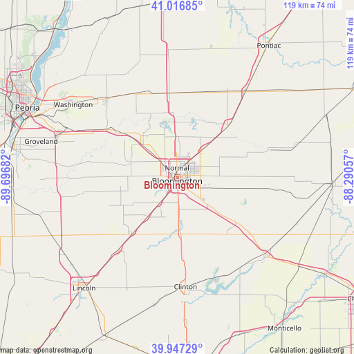
Bloomington GPS coordinates[2]
40° 29' 3.12" North, 88° 59' 37.284" West
| Map corner | latitude | longitude |
|---|---|---|
| Upper-left | 41.01685°, | -89.69682° |
| Center: | 40.4842°, | -88.99369° |
| Lower-right: | 39.94729°, | -88.29057° |
| Map W x H: | 118.9×118.9 km | = 73.9×73.9mi |
| max Lat: | 71.29058° ⇑41.3% North |
| Bloomington: | 40.4842° |
| min Lat: | ⇓58.7% South 19.06759° |
| min Long | Bloomington | max Long |
| -171.73463° | -88.99369° | -66.98998° |
| W 43.9%⇐ | ⇒56.1% E |
Elevation
Elevation of Bloomington is 246 m = 807 ft, and this is 48.8 m = 160 ft below average elevation for this country.
| Max E: |
3189 m = 10463 ft | 38.6% |
| Avg. | 294.8 m = 967 ft | |
| Bloomington | 246 m = 807 ft | |
Min E: |
-60 m = -197 ft | 61.4% |
See also: Bloomington elevation on elevation.city.
Geographical zone
Bloomington is located in North temperate zone (between Tropic of Cancer and the Arctic Circle). Distance of this Northern Tropic circle is 1895.5 km =1177.8 mi to South.| Distance of | km | miles | from Bloomington |
|---|---|---|---|
| North Pole | 5505.6 | 3421 | to North |
| Arctic Circle | 2899.8 | 1801.9 | to North |
| Tropic Cancer | 1895.5 | 1177.8 | to South |
| Equator | 4501.4 | 2797 | to South |


Nearby cities:
15 places around Bloomington: (largest is in red/bold)
• Carlock
16 km =9.9 mi,  313°
313°
• Danvers
16.3 km =10.1 mi,  287°
287°
• Downs
14.2 km =8.8 mi,  132°
132°
• El Paso
28.4 km =17.6 mi,  356°
356°
• Goodfield
28.7 km =17.8 mi,  304°
304°
• Heyworth
19.1 km =11.9 mi,  174°
174°
• Hudson
13.5 km =8.4 mi,  2°
2°
• Le Roy
24.4 km =15.2 mi, 127°
• Lexington
24.9 km =15.5 mi,  45°
45°
• McLean
24.1 km =15 mi,  218°
218°
• Minier
27.6 km =17.1 mi,  258°
258°
• Normal
3.3 km =2.1 mi, 4°
• Pleasant Hill
25.3 km =15.7 mi,  55°
55°
• Stanford
19.7 km =12.2 mi,  253°
253°
• Twin Grove
7.4 km =4.6 mi,  277°
277°
Sources, notices
• [Note1] Compared only with cities in United States existing in our database
• [Src1] Map data: © OpenStreetMap contributors (CC-BY-SA)
• [Src2] Other city data from geonames.org with taken over terms of usage.
• [Src3] Geographical zone / Annual Mean Temperature by Robert A. Rohde @ Wikipedia
