Le Roy geodata
Le Roy (Illinois) is a populated place; located in United States in America/Chicago (GMT-5) time zone. With population of 3,582 people, there are 8748 cities with bigger population in this country. Compared to other cities in United States, 57.3% of cities are located further ↓South; 55.5% of cities are located further →East and 60.5% of cities have lower elevation than Le Roy. Note1


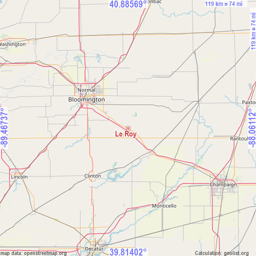
Le Roy GPS coordinates[2]
40° 21' 7.128" North, 88° 45' 51.264" West
| Map corner | latitude | longitude |
|---|---|---|
| Upper-left | 40.88569°, | -89.46737° |
| Center: | 40.35198°, | -88.76424° |
| Lower-right: | 39.81402°, | -88.06112° |
| Map W x H: | 119.2×119.2 km | = 74.1×74.1mi |
| max Lat: | 71.29058° ⇑42.7% North |
| Le Roy: | 40.35198° |
| min Lat: | ⇓57.3% South 19.06759° |
| min Long | Le Roy | max Long |
| -171.73463° | -88.76424° | -66.98998° |
| W 44.5%⇐ | ⇒55.5% E |
Elevation
Elevation of Le Roy is 242 m = 794 ft, and this is 52.8 m = 173 ft below average elevation for this country.
| Max E: |
3189 m = 10463 ft | 39.5% |
| Avg. | 294.8 m = 967 ft | |
| Le Roy | 242 m = 794 ft | |
Min E: |
-60 m = -197 ft | 60.5% |
See also: United States elevation on elevation.city.
Geographical zone
Le Roy is located in North temperate zone (between Tropic of Cancer and the Arctic Circle). Distance of this Northern Tropic circle is 1880.8 km =1168.7 mi to South.| Distance of | km | miles | from Le Roy |
|---|---|---|---|
| North Pole | 5520.3 | 3430.2 | to North |
| Arctic Circle | 2914.5 | 1811 | to North |
| Tropic Cancer | 1880.8 | 1168.7 | to South |
| Equator | 4486.7 | 2787.9 | to South |


Nearby cities:
15 places around Le Roy: (largest is in red/bold)
• Bloomington
24.4 km =15.2 mi,  307°
307°
• Clinton
27.8 km =17.3 mi,  217°
217°
• Colfax
27 km =16.8 mi,  27°
27°
• Downs
10.3 km =6.4 mi,  299°
299°
• Farmer City
15.9 km =9.9 mi,  139°
139°
• Gibson City
34.3 km =21.3 mi,  69°
69°
• Heyworth
18.3 km =11.4 mi,  256°
256°
• Hudson
34 km =21.1 mi,  326°
326°
• Lexington
32.2 km =20 mi,  357°
357°
• Mansfield
26.9 km =16.7 mi,  125°
125°
• Normal
26.3 km =16.3 mi, 313°
• Pleasant Hill
29.1 km =18.1 mi,  2°
2°
• Saybrook
21.8 km =13.5 mi, 67°
• Twin Grove
31 km =19.3 mi, 300°
• Wapella
22.3 km =13.9 mi,  228°
228°
Sources, notices
• [Note1] Compared only with cities in United States existing in our database
• [Src1] Map data: © OpenStreetMap contributors (CC-BY-SA)
• [Src2] Other city data from geonames.org with taken over terms of usage.
• [Src3] Geographical zone / Annual Mean Temperature by Robert A. Rohde @ Wikipedia
