Normal geodata
Normal (Illinois) is a populated place; located in United States in America/Chicago (GMT-5) time zone. With population of 54,373 people, there are 855 cities with bigger population in this country. Compared to other cities in United States, 59% of cities are located further ↓South; 56.1% of cities are located further →East and 61.9% of cities have lower elevation than Normal. Note1


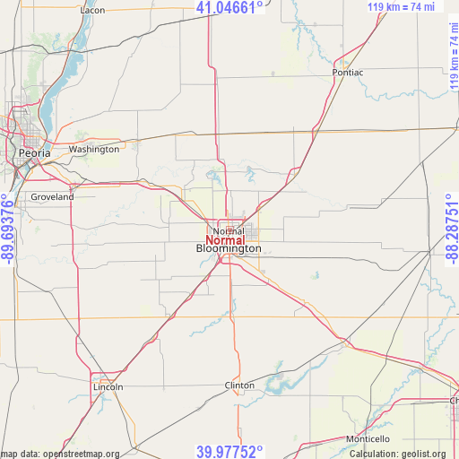
Normal GPS coordinates[2]
40° 30' 51.12" North, 88° 59' 26.268" West
| Map corner | latitude | longitude |
|---|---|---|
| Upper-left | 41.04661°, | -89.69376° |
| Center: | 40.5142°, | -88.99063° |
| Lower-right: | 39.97752°, | -88.28751° |
| Map W x H: | 118.9×118.9 km | = 73.9×73.9mi |
| max Lat: | 71.29058° ⇑41% North |
| Normal: | 40.5142° |
| min Lat: | ⇓59% South 19.06759° |
| min Long | Normal | max Long |
| -171.73463° | -88.99063° | -66.98998° |
| W 43.9%⇐ | ⇒56.1% E |
Elevation
Elevation of Normal is 248 m = 814 ft, and this is 46.8 m = 154 ft below average elevation for this country.
| Max E: |
3189 m = 10463 ft | 38.1% |
| Avg. | 294.8 m = 967 ft | |
| Normal | 248 m = 814 ft | |
Min E: |
-60 m = -197 ft | 61.9% |
See also: Normal elevation on elevation.city.
Geographical zone
Normal is located in North temperate zone (between Tropic of Cancer and the Arctic Circle). Distance of this Northern Tropic circle is 1898.8 km =1179.9 mi to South.| Distance of | km | miles | from Normal |
|---|---|---|---|
| North Pole | 5502.3 | 3419 | to North |
| Arctic Circle | 2896.4 | 1799.7 | to North |
| Tropic Cancer | 1898.8 | 1179.9 | to South |
| Equator | 4504.8 | 2799.2 | to South |


Nearby cities:
15 places around Normal: (largest is in red/bold)
• Bloomington
3.3 km =2.1 mi,  184°
184°
• Carlock
14.1 km =8.8 mi,  302°
302°
• Danvers
15.9 km =9.9 mi,  276°
276°
• Downs
16.5 km =10.3 mi,  142°
142°
• El Paso
25.1 km =15.6 mi,  355°
355°
• Goodfield
27.2 km =16.9 mi, 298°
• Gridley
27.1 km =16.8 mi,  19°
19°
• Heyworth
22.4 km =13.9 mi, 176°
• Hudson
10.2 km =6.3 mi,  1°
1°
• Le Roy
26.3 km =16.3 mi,  133°
133°
• Lexington
22.5 km =14 mi,  51°
51°
• McLean
26.9 km =16.7 mi,  214°
214°
• Pleasant Hill
23.3 km =14.5 mi,  61°
61°
• Stanford
21.2 km =13.2 mi,  245°
245°
• Twin Grove
7.9 km =4.9 mi, 252°
Sources, notices
• [Note1] Compared only with cities in United States existing in our database
• [Src1] Map data: © OpenStreetMap contributors (CC-BY-SA)
• [Src2] Other city data from geonames.org with taken over terms of usage.
• [Src3] Geographical zone / Annual Mean Temperature by Robert A. Rohde @ Wikipedia
