Plainfield geodata
Plainfield (Illinois) is a populated place; located in United States in America/Chicago (GMT-5) time zone. With population of 42,527 people, there are 1128 cities with bigger population in this country. Compared to other cities in United States, 72.1% of cities are located further ↓South; 53.7% of cities are located further →East and 52.5% of cities have higher elevation than Plainfield. Note1


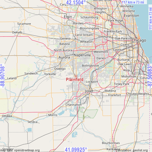
Plainfield GPS coordinates[2]
41° 37' 37.092" North, 88° 12' 14.22" West
| Map corner | latitude | longitude |
|---|---|---|
| Upper-left | 42.1504°, | -88.90708° |
| Center: | 41.62697°, | -88.20395° |
| Lower-right: | 41.09925°, | -87.50083° |
| Map W x H: | 116.9×116.9 km | = 72.6×72.6mi |
| max Lat: | 71.29058° ⇑27.9% North |
| Plainfield: | 41.62697° |
| min Lat: | ⇓72.1% South 19.06759° |
| min Long | Plainfield | max Long |
| -171.73463° | -88.20395° | -66.98998° |
| W 46.3%⇐ | ⇒53.7% E |
Elevation
Elevation of Plainfield is 189 m = 620 ft, and this is 105.8 m = 347 ft below average elevation for this country.
| Max E: |
3189 m = 10463 ft | 52.5% |
| Avg. | 294.8 m = 967 ft | |
| Plainfield | 189 m = 620 ft | |
Min E: |
-60 m = -197 ft | 47.5% |
See also: Plainfield elevation on elevation.city.
Geographical zone
Plainfield is located in North temperate zone (between Tropic of Cancer and the Arctic Circle). Distance of this Northern Tropic circle is 2022.6 km =1256.8 mi to South.| Distance of | km | miles | from Plainfield |
|---|---|---|---|
| North Pole | 5378.6 | 3342.1 | to North |
| Arctic Circle | 2772.7 | 1722.9 | to North |
| Tropic Cancer | 2022.6 | 1256.8 | to South |
| Equator | 4628.5 | 2876 | to South |


Nearby cities:
15 places around Plainfield: (largest is in red/bold)
• Bolingbrook
13.8 km =8.6 mi,  54°
54°
• Boulder Hill
14.5 km =9 mi,  310°
310°
• Crest Hill
11.9 km =7.4 mi,  132°
132°
• Crystal Lawns
7.4 km =4.6 mi,  148°
148°
• Fairmont
14.4 km =8.9 mi,  123°
123°
• Ingalls Park
17.7 km =11 mi, 130°
• Joliet
15.1 km =9.4 mi,  138°
138°
• Lemont
17.6 km =10.9 mi,  72°
72°
• Lockport
12.8 km =8 mi,  108°
108°
• Lynwood
17 km =10.6 mi,  291°
291°
• Montgomery
16.5 km =10.3 mi, 314°
• Oswego
13.7 km =8.5 mi,  296°
296°
• Rockdale
15.4 km =9.6 mi, 151°
• Romeoville
9.8 km =6.1 mi,  76°
76°
• Shorewood
11.9 km =7.4 mi,  179°
179°
Sources, notices
• [Note1] Compared only with cities in United States existing in our database
• [Src1] Map data: © OpenStreetMap contributors (CC-BY-SA)
• [Src2] Other city data from geonames.org with taken over terms of usage.
• [Src3] Geographical zone / Annual Mean Temperature by Robert A. Rohde @ Wikipedia
