Altona geodata
Altona (Illinois) is a populated place; located in United States in America/Chicago (GMT-5) time zone. With population of 511 people, there are 20745 cities with bigger population in this country. Compared to other cities in United States, 67% of cities are located further ↓South; 59.5% of cities are located further →East and 58.8% of cities have lower elevation than Altona. Note1
Administrative division(s):
- Level 1: Illinois
- Level 2: Knox County
- Level 3: Township of Walnut Grove


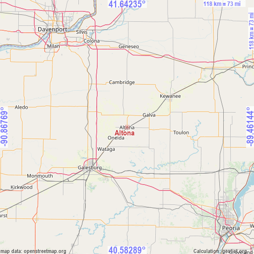
Altona GPS coordinates[2]
41° 6' 53.136" North, 90° 9' 52.416" West
| Map corner | latitude | longitude |
|---|---|---|
| Upper-left | 41.64235°, | -90.86769° |
| Center: | 41.11476°, | -90.16456° |
| Lower-right: | 40.58289°, | -89.46144° |
| Map W x H: | 117.8×117.8 km | = 73.2×73.2mi |
| max Lat: | 71.29058° ⇑33% North |
| Altona: | 41.11476° |
| min Lat: | ⇓67% South 19.06759° |
| min Long | Altona | max Long |
| -171.73463° | -90.16456° | -66.98998° |
| W 40.5%⇐ | ⇒59.5% E |
Elevation
Elevation of Altona is 234 m = 768 ft, and this is 60.8 m = 199 ft below average elevation for this country.
| Max E: |
3189 m = 10463 ft | 41.2% |
| Avg. | 294.8 m = 967 ft | |
| Altona | 234 m = 768 ft | |
Min E: |
-60 m = -197 ft | 58.8% |
See also: United States elevation on elevation.city.
Geographical zone
Altona is located in North temperate zone (between Tropic of Cancer and the Arctic Circle). Distance of this Northern Tropic circle is 1965.6 km =1221.4 mi to South.| Distance of | km | miles | from Altona |
|---|---|---|---|
| North Pole | 5435.5 | 3377.5 | to North |
| Arctic Circle | 2829.6 | 1758.2 | to North |
| Tropic Cancer | 1965.6 | 1221.4 | to South |
| Equator | 4571.5 | 2840.6 | to South |


Nearby cities:
15 places around Altona: (largest is in red/bold)
• Alpha
20 km =12.4 mi,  295°
295°
• Andover
22.6 km =14 mi,  331°
331°
• Cambridge
21.1 km =13.1 mi,  353°
353°
• East Galesburg
22.2 km =13.8 mi,  213°
213°
• Galesburg
25.4 km =15.8 mi,  223°
223°
• Galva
11.8 km =7.3 mi,  60°
60°
• Kewanee
24.8 km =15.4 mi,  54°
54°
• Knoxville
25.1 km =15.6 mi,  203°
203°
• New Windsor
25.2 km =15.7 mi,  292°
292°
• Oak Run
16.9 km =10.5 mi,  174°
174°
• Oneida
7 km =4.3 mi,  227°
227°
• Toulon
25.2 km =15.7 mi,  95°
95°
• Wataga
13.9 km =8.6 mi, 224°
• Williamsfield
24.8 km =15.4 mi,  149°
149°
• Woodhull
14.5 km =9 mi, 299°
Sources, notices
• [Note1] Compared only with cities in United States existing in our database
• [Src1] Map data: © OpenStreetMap contributors (CC-BY-SA)
• [Src2] Other city data from geonames.org with taken over terms of usage.
• [Src3] Geographical zone / Annual Mean Temperature by Robert A. Rohde @ Wikipedia
