Andover geodata
Andover (Illinois) is a populated place; located in United States in America/Chicago (GMT-5) time zone. With population of 573 people, there are 19993 cities with bigger population in this country. Compared to other cities in United States, 68.8% of cities are located further ↓South; 59.9% of cities are located further →East and 59.9% of cities have lower elevation than Andover. Note1


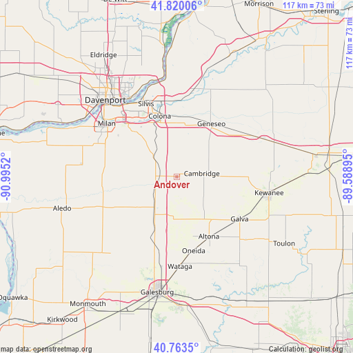
Andover GPS coordinates[2]
41° 17' 38.112" North, 90° 17' 31.452" West
| Map corner | latitude | longitude |
|---|---|---|
| Upper-left | 41.82006°, | -90.9952° |
| Center: | 41.29392°, | -90.29207° |
| Lower-right: | 40.7635°, | -89.58895° |
| Map W x H: | 117.5×117.5 km | = 73×73mi |
| max Lat: | 71.29058° ⇑31.2% North |
| Andover: | 41.29392° |
| min Lat: | ⇓68.8% South 19.06759° |
| min Long | Andover | max Long |
| -171.73463° | -90.29207° | -66.98998° |
| W 40.1%⇐ | ⇒59.9% E |
Elevation
Elevation of Andover is 239 m = 784 ft, and this is 55.8 m = 183 ft below average elevation for this country.
| Max E: |
3189 m = 10463 ft | 40.1% |
| Avg. | 294.8 m = 967 ft | |
| Andover | 239 m = 784 ft | |
Min E: |
-60 m = -197 ft | 59.9% |
See also: United States elevation on elevation.city.
Geographical zone
Andover is located in North temperate zone (between Tropic of Cancer and the Arctic Circle). Distance of this Northern Tropic circle is 1985.5 km =1233.7 mi to South.| Distance of | km | miles | from Andover |
|---|---|---|---|
| North Pole | 5415.6 | 3365.1 | to North |
| Arctic Circle | 2809.7 | 1745.9 | to North |
| Tropic Cancer | 1985.5 | 1233.7 | to South |
| Equator | 4591.5 | 2853 | to South |


Nearby cities:
15 places around Andover: (largest is in red/bold)
• Alpha
13.5 km =8.4 mi,  212°
212°
• Altona
22.6 km =14 mi,  151°
151°
• Cambridge
8.4 km =5.2 mi,  82°
82°
• Carbon Cliff
23.8 km =14.8 mi,  339°
339°
• Coal Valley
20.6 km =12.8 mi,  316°
316°
• Colona
21.7 km =13.5 mi,  346°
346°
• Coyne Center
25.5 km =15.8 mi,  298°
298°
• Galva
25.2 km =15.7 mi,  123°
123°
• Geneseo
20.6 km =12.8 mi,  33°
33°
• Green Rock
20.7 km =12.9 mi, 344°
• New Windsor
16.2 km =10.1 mi,  230°
230°
• Oneida
25.3 km =15.7 mi,  167°
167°
• Orion
10.1 km =6.3 mi,  312°
312°
• Sherrard
18.1 km =11.2 mi,  278°
278°
• Woodhull
12.9 km =8 mi,  188°
188°
Sources, notices
• [Note1] Compared only with cities in United States existing in our database
• [Src1] Map data: © OpenStreetMap contributors (CC-BY-SA)
• [Src2] Other city data from geonames.org with taken over terms of usage.
• [Src3] Geographical zone / Annual Mean Temperature by Robert A. Rohde @ Wikipedia
