Lemont geodata
Lemont (Illinois) is a populated place; located in United States in America/Chicago (GMT-5) time zone. With population of 16,788 people, there are 2924 cities with bigger population in this country. Compared to other cities in United States, 72.6% of cities are located further ↓South; 52.9% of cities are located further →East and 53.1% of cities have higher elevation than Lemont. Note1


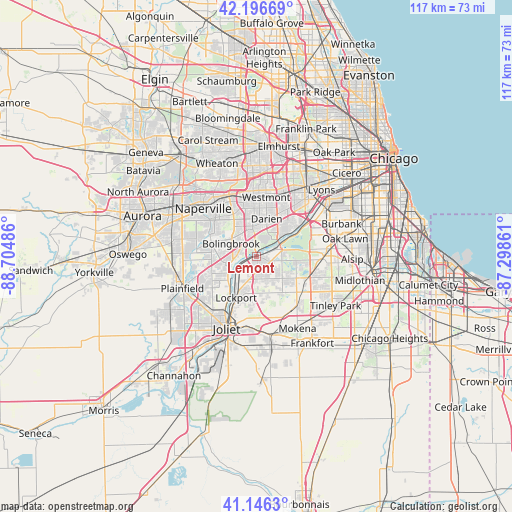
Lemont GPS coordinates[2]
41° 40' 25.104" North, 88° 0' 6.228" West
| Map corner | latitude | longitude |
|---|---|---|
| Upper-left | 42.19669°, | -88.70486° |
| Center: | 41.67364°, | -88.00173° |
| Lower-right: | 41.1463°, | -87.29861° |
| Map W x H: | 116.8×116.8 km | = 72.6×72.6mi |
| max Lat: | 71.29058° ⇑27.4% North |
| Lemont: | 41.67364° |
| min Lat: | ⇓72.6% South 19.06759° |
| min Long | Lemont | max Long |
| -171.73463° | -88.00173° | -66.98998° |
| W 47.1%⇐ | ⇒52.9% E |
Elevation
Elevation of Lemont is 187 m = 614 ft, and this is 107.8 m = 354 ft below average elevation for this country.
| Max E: |
3189 m = 10463 ft | 53.1% |
| Avg. | 294.8 m = 967 ft | |
| Lemont | 187 m = 614 ft | |
Min E: |
-60 m = -197 ft | 46.9% |
See also: United States elevation on elevation.city.
Geographical zone
Lemont is located in North temperate zone (between Tropic of Cancer and the Arctic Circle). Distance of this Northern Tropic circle is 2027.8 km =1260 mi to South.| Distance of | km | miles | from Lemont |
|---|---|---|---|
| North Pole | 5373.4 | 3338.9 | to North |
| Arctic Circle | 2767.5 | 1719.6 | to North |
| Tropic Cancer | 2027.8 | 1260 | to South |
| Equator | 4633.7 | 2879.2 | to South |


Nearby cities:
15 places around Lemont: (largest is in red/bold)
• Bolingbrook
6.2 km =3.9 mi,  296°
296°
• Burr Ridge
10.9 km =6.8 mi,  39°
39°
• Clarendon Hills
14.3 km =8.9 mi,  15°
15°
• Darien
9 km =5.6 mi,  14°
14°
• Fairmont
13.9 km =8.6 mi,  200°
200°
• Goodings Grove
7.7 km =4.8 mi,  130°
130°
• Homer Glen
9.7 km =6 mi,  147°
147°
• Indian Head Park
13.6 km =8.5 mi, 37°
• Lockport
10.5 km =6.5 mi,  206°
206°
• Orland Park
13.2 km =8.2 mi,  111°
111°
• Romeoville
7.8 km =4.8 mi,  248°
248°
• Westmont
13.8 km =8.6 mi, 9°
• Willow Springs
13.9 km =8.6 mi,  57°
57°
• Willowbrook
12 km =7.5 mi,  27°
27°
• Woodridge
9.1 km =5.7 mi,  333°
333°
Sources, notices
• [Note1] Compared only with cities in United States existing in our database
• [Src1] Map data: © OpenStreetMap contributors (CC-BY-SA)
• [Src2] Other city data from geonames.org with taken over terms of usage.
• [Src3] Geographical zone / Annual Mean Temperature by Robert A. Rohde @ Wikipedia
