Bolingbrook geodata
Bolingbrook (Illinois) is a populated place; located in United States in America/Chicago (GMT-5) time zone. With population of 74,306 people, there are 548 cities with bigger population in this country. Compared to other cities in United States, 72.9% of cities are located further ↓South; 53.2% of cities are located further →East and 54.4% of cities have lower elevation than Bolingbrook. Note1


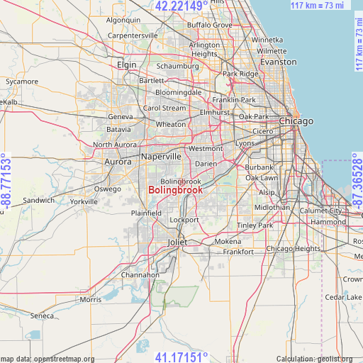
Bolingbrook GPS coordinates[2]
41° 41' 55.104" North, 88° 4' 6.24" West
| Map corner | latitude | longitude |
|---|---|---|
| Upper-left | 42.22149°, | -88.77153° |
| Center: | 41.69864°, | -88.0684° |
| Lower-right: | 41.17151°, | -87.36528° |
| Map W x H: | 116.7×116.7 km | = 72.5×72.5mi |
| max Lat: | 71.29058° ⇑27.1% North |
| Bolingbrook: | 41.69864° |
| min Lat: | ⇓72.9% South 19.06759° |
| min Long | Bolingbrook | max Long |
| -171.73463° | -88.0684° | -66.98998° |
| W 46.8%⇐ | ⇒53.2% E |
Elevation
Elevation of Bolingbrook is 216 m = 709 ft, and this is 78.8 m = 259 ft below average elevation for this country.
| Max E: |
3189 m = 10463 ft | 45.6% |
| Avg. | 294.8 m = 967 ft | |
| Bolingbrook | 216 m = 709 ft | |
Min E: |
-60 m = -197 ft | 54.4% |
See also: Bolingbrook elevation on elevation.city.
Geographical zone
Bolingbrook is located in North temperate zone (between Tropic of Cancer and the Arctic Circle). Distance of this Northern Tropic circle is 2030.5 km =1261.7 mi to South.| Distance of | km | miles | from Bolingbrook |
|---|---|---|---|
| North Pole | 5370.6 | 3337.1 | to North |
| Arctic Circle | 2764.7 | 1717.9 | to North |
| Tropic Cancer | 2030.5 | 1261.7 | to South |
| Equator | 4636.5 | 2881 | to South |


Nearby cities:
15 places around Bolingbrook: (largest is in red/bold)
• Burr Ridge
13.6 km =8.5 mi,  65°
65°
• Clarendon Hills
14.5 km =9 mi,  40°
40°
• Darien
9.8 km =6.1 mi,  52°
52°
• Downers Grove
13.1 km =8.1 mi,  21°
21°
• Goodings Grove
13.8 km =8.6 mi,  124°
124°
• Homer Glen
15.4 km =9.6 mi,  135°
135°
• Lemont
6.2 km =3.9 mi, 116°
• Lisle
11.4 km =7.1 mi,  357°
357°
• Lockport
12.2 km =7.6 mi,  175°
175°
• Naperville
11.7 km =7.3 mi,  325°
325°
• Plainfield
13.8 km =8.6 mi,  234°
234°
• Romeoville
5.9 km =3.7 mi,  197°
197°
• Westmont
13.3 km =8.3 mi, 35°
• Willowbrook
13.5 km =8.4 mi, 54°
• Woodridge
5.6 km =3.5 mi, 15°
Sources, notices
• [Note1] Compared only with cities in United States existing in our database
• [Src1] Map data: © OpenStreetMap contributors (CC-BY-SA)
• [Src2] Other city data from geonames.org with taken over terms of usage.
• [Src3] Geographical zone / Annual Mean Temperature by Robert A. Rohde @ Wikipedia
