Milledgeville geodata
Milledgeville (Illinois) is a populated place; located in United States in America/Chicago (GMT-5) time zone. With population of 983 people, there are 16389 cities with bigger population in this country. Compared to other cities in United States, 75.4% of cities are located further ↓South; 58.4% of cities are located further →East and 58.6% of cities have lower elevation than Milledgeville. Note1


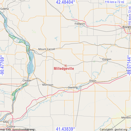
Milledgeville GPS coordinates[2]
41° 57' 48.096" North, 89° 46' 28.416" West
| Map corner | latitude | longitude |
|---|---|---|
| Upper-left | 42.48404°, | -90.47769° |
| Center: | 41.96336°, | -89.77456° |
| Lower-right: | 41.43839°, | -89.07144° |
| Map W x H: | 116.3×116.3 km | = 72.3×72.3mi |
| max Lat: | 71.29058° ⇑24.6% North |
| Milledgeville: | 41.96336° |
| min Lat: | ⇓75.4% South 19.06759° |
| min Long | Milledgeville | max Long |
| -171.73463° | -89.77456° | -66.98998° |
| W 41.6%⇐ | ⇒58.4% E |
Elevation
Elevation of Milledgeville is 233 m = 764 ft, and this is 61.8 m = 203 ft below average elevation for this country.
| Max E: |
3189 m = 10463 ft | 41.4% |
| Avg. | 294.8 m = 967 ft | |
| Milledgeville | 233 m = 764 ft | |
Min E: |
-60 m = -197 ft | 58.6% |
See also: United States elevation on elevation.city.
Geographical zone
Milledgeville is located in North temperate zone (between Tropic of Cancer and the Arctic Circle). Distance of this Northern Tropic circle is 2060 km =1280 mi to South.| Distance of | km | miles | from Milledgeville |
|---|---|---|---|
| North Pole | 5341.2 | 3318.9 | to North |
| Arctic Circle | 2735.3 | 1699.6 | to North |
| Tropic Cancer | 2060 | 1280 | to South |
| Equator | 4665.9 | 2899.3 | to South |


Nearby cities:
15 places around Milledgeville: (largest is in red/bold)
• Chadwick
11.1 km =6.9 mi,  300°
300°
• Como
21.9 km =13.6 mi,  178°
178°
• Dixon
28.1 km =17.5 mi,  119°
119°
• Forreston
24.2 km =15 mi,  41°
41°
• Georgetown
20.1 km =12.5 mi,  347°
347°
• Lanark
16.2 km =10.1 mi,  342°
342°
• Morrison
23.2 km =14.4 mi,  222°
222°
• Mount Carroll
22.3 km =13.9 mi,  311°
311°
• Mount Morris
30 km =18.6 mi,  71°
71°
• Palmyra
20.5 km =12.7 mi,  127°
127°
• Polo
16.3 km =10.1 mi,  81°
81°
• Rock Falls
21.6 km =13.4 mi,  160°
160°
• Shannon
21.5 km =13.4 mi,  7°
7°
• Sterling
20.5 km =12.7 mi, 161°
• Thomson
26.9 km =16.7 mi,  268°
268°
Sources, notices
• [Note1] Compared only with cities in United States existing in our database
• [Src1] Map data: © OpenStreetMap contributors (CC-BY-SA)
• [Src2] Other city data from geonames.org with taken over terms of usage.
• [Src3] Geographical zone / Annual Mean Temperature by Robert A. Rohde @ Wikipedia
