Pecatonica geodata
Pecatonica (Illinois) is a populated place; located in United States in America/Chicago (GMT-5) time zone. With population of 2,124 people, there are 11543 cities with bigger population in this country. Compared to other cities in United States, 78.2% of cities are located further ↓South; 57.2% of cities are located further →East and 58.6% of cities have lower elevation than Pecatonica. Note1
Administrative division(s):
- Level 1: Illinois
- Level 2: Winnebago County
- Level 3: Township of Pecatonica


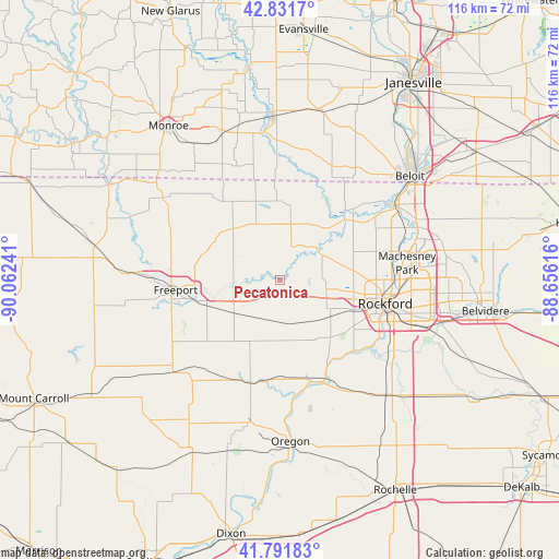
Pecatonica GPS coordinates[2]
42° 18' 50.076" North, 89° 21' 33.408" West
| Map corner | latitude | longitude |
|---|---|---|
| Upper-left | 42.8317°, | -90.06241° |
| Center: | 42.31391°, | -89.35928° |
| Lower-right: | 41.79183°, | -88.65616° |
| Map W x H: | 115.6×115.6 km | = 71.8×71.8mi |
| max Lat: | 71.29058° ⇑21.8% North |
| Pecatonica: | 42.31391° |
| min Lat: | ⇓78.2% South 19.06759° |
| min Long | Pecatonica | max Long |
| -171.73463° | -89.35928° | -66.98998° |
| W 42.8%⇐ | ⇒57.2% E |
Elevation
Elevation of Pecatonica is 233 m = 764 ft, and this is 61.8 m = 203 ft below average elevation for this country.
| Max E: |
3189 m = 10463 ft | 41.4% |
| Avg. | 294.8 m = 967 ft | |
| Pecatonica | 233 m = 764 ft | |
Min E: |
-60 m = -197 ft | 58.6% |
See also: United States elevation on elevation.city.
Geographical zone
Pecatonica is located in North temperate zone (between Tropic of Cancer and the Arctic Circle). Distance of this Northern Tropic circle is 2098.9 km =1304.2 mi to South.| Distance of | km | miles | from Pecatonica |
|---|---|---|---|
| North Pole | 5302.2 | 3294.6 | to North |
| Arctic Circle | 2696.3 | 1675.4 | to North |
| Tropic Cancer | 2098.9 | 1304.2 | to South |
| Equator | 4704.9 | 2923.5 | to South |


Nearby cities:
15 places around Pecatonica: (largest is in red/bold)
• Byron
22.5 km =14 mi,  157°
157°
• Cedarville
23.5 km =14.6 mi,  287°
287°
• Davis
12.9 km =8 mi,  339°
339°
• Durand
13.8 km =8.6 mi,  9°
9°
• Forreston
27.6 km =17.1 mi,  220°
220°
• Freeport
21.6 km =13.4 mi,  264°
264°
• Lake Summerset
15.8 km =9.8 mi,  350°
350°
• Loves Park
24.8 km =15.4 mi,  88°
88°
• Machesney Park
26.6 km =16.5 mi,  81°
81°
• New Milford
27.8 km =17.3 mi,  120°
120°
• Orangeville
29 km =18 mi,  306°
306°
• Rockford
22.3 km =13.9 mi,  102°
102°
• Rockton
28.2 km =17.5 mi,  56°
56°
• Stillman Valley
27.3 km =17 mi,  147°
147°
• Winnebago
11.1 km =6.9 mi, 118°
Sources, notices
• [Note1] Compared only with cities in United States existing in our database
• [Src1] Map data: © OpenStreetMap contributors (CC-BY-SA)
• [Src2] Other city data from geonames.org with taken over terms of usage.
• [Src3] Geographical zone / Annual Mean Temperature by Robert A. Rohde @ Wikipedia
