Flanagan geodata
Flanagan (Illinois) is a populated place; located in United States in America/Chicago (GMT-5) time zone. With population of 1,082 people, there are 15773 cities with bigger population in this country. Compared to other cities in United States, 64.4% of cities are located further ↓South; 55.8% of cities are located further →East and 52.2% of cities have lower elevation than Flanagan. Note1
Administrative division(s):
- Level 1: Illinois
- Level 2: Livingston County
- Level 3: Township of Nebraska


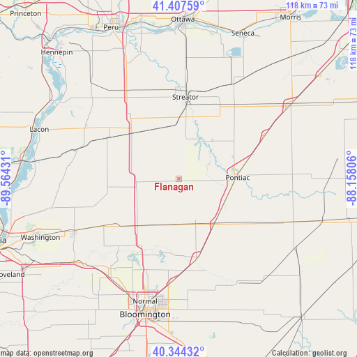
Flanagan GPS coordinates[2]
40° 52' 41.124" North, 88° 51' 40.248" West
| Map corner | latitude | longitude |
|---|---|---|
| Upper-left | 41.40759°, | -89.56431° |
| Center: | 40.87809°, | -88.86118° |
| Lower-right: | 40.34432°, | -88.15806° |
| Map W x H: | 118.2×118.2 km | = 73.4×73.4mi |
| max Lat: | 71.29058° ⇑35.6% North |
| Flanagan: | 40.87809° |
| min Lat: | ⇓64.4% South 19.06759° |
| min Long | Flanagan | max Long |
| -171.73463° | -88.86118° | -66.98998° |
| W 44.2%⇐ | ⇒55.8% E |
Elevation
Elevation of Flanagan is 207 m = 679 ft, and this is 87.8 m = 288 ft below average elevation for this country.
| Max E: |
3189 m = 10463 ft | 47.8% |
| Avg. | 294.8 m = 967 ft | |
| Flanagan | 207 m = 679 ft | |
Min E: |
-60 m = -197 ft | 52.2% |
See also: United States elevation on elevation.city.
Geographical zone
Flanagan is located in North temperate zone (between Tropic of Cancer and the Arctic Circle). Distance of this Northern Tropic circle is 1939.3 km =1205 mi to South.| Distance of | km | miles | from Flanagan |
|---|---|---|---|
| North Pole | 5461.8 | 3393.8 | to North |
| Arctic Circle | 2856 | 1774.6 | to North |
| Tropic Cancer | 1939.3 | 1205 | to South |
| Equator | 4545.2 | 2824.3 | to South |


Nearby cities:
15 places around Flanagan: (largest is in red/bold)
• Chenoa
19.3 km =12 mi,  141°
141°
• El Paso
20.2 km =12.6 mi,  220°
220°
• Fairbury
32.6 km =20.3 mi,  116°
116°
• Gridley
15.1 km =9.4 mi,  186°
186°
• Hudson
32.1 km =19.9 mi,  199°
199°
• Lexington
27.1 km =16.8 mi,  166°
166°
• Minonk
14.9 km =9.3 mi,  281°
281°
• Odell
31.5 km =19.6 mi,  63°
63°
• Pleasant Hill
31 km =19.3 mi,  161°
161°
• Pontiac
19.5 km =12.1 mi,  89°
89°
• Roanoke
29.7 km =18.5 mi,  252°
252°
• Streator
27.1 km =16.8 mi,  4°
4°
• Toluca
26.7 km =16.6 mi,  301°
301°
• Washburn
36.4 km =22.6 mi, 277°
• Wenona
25.1 km =15.6 mi,  320°
320°
Sources, notices
• [Note1] Compared only with cities in United States existing in our database
• [Src1] Map data: © OpenStreetMap contributors (CC-BY-SA)
• [Src2] Other city data from geonames.org with taken over terms of usage.
• [Src3] Geographical zone / Annual Mean Temperature by Robert A. Rohde @ Wikipedia
