Urbana geodata
Urbana (Illinois) is a seat of a second-order administrative division; located in United States in America/Chicago (GMT-5) time zone. With population of 42,311 people, there are 1131 cities with bigger population in this country. Compared to other cities in United States, 54.7% of cities are located further ↓South; 53.8% of cities are located further →East and 57.7% of cities have lower elevation than Urbana. Note1
Administrative division(s):
- Level 1: Illinois
- Level 2: Champaign County
- Level 3: Township of Cunningham


Urbana GPS coordinates[2]
40° 6' 38.124" North, 88° 12' 26.172" West
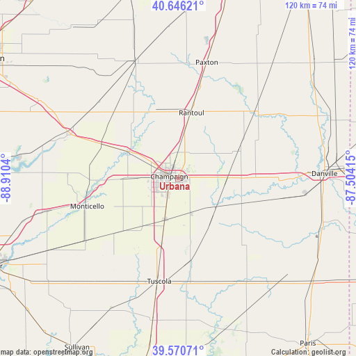
| Map corner | latitude | longitude |
|---|---|---|
| Upper-left | 40.64621°, | -88.9104° |
| Center: | 40.11059°, | -88.20727° |
| Lower-right: | 39.57071°, | -87.50415° |
| Map W x H: | 119.6×119.6 km | = 74.3×74.3mi |
| max Lat: | 71.29058° ⇑45.3% North |
| Urbana: | 40.11059° |
| min Lat: | ⇓54.7% South 19.06759° |
| min Long | Urbana | max Long |
| -171.73463° | -88.20727° | -66.98998° |
| W 46.2%⇐ | ⇒53.8% E |
Elevation
Elevation of Urbana is 229 m = 751 ft, and this is 65.8 m = 216 ft below average elevation for this country.
| Max E: |
3189 m = 10463 ft | 42.3% |
| Avg. | 294.8 m = 967 ft | |
| Urbana | 229 m = 751 ft | |
Min E: |
-60 m = -197 ft | 57.7% |
See also: Urbana elevation on elevation.city.
Geographical zone
Urbana is located in North temperate zone (between Tropic of Cancer and the Arctic Circle). Distance of this Northern Tropic circle is 1854 km =1152 mi to South.| Distance of | km | miles | from Urbana |
|---|---|---|---|
| North Pole | 5547.2 | 3446.9 | to North |
| Arctic Circle | 2941.3 | 1827.6 | to North |
| Tropic Cancer | 1854 | 1152 | to South |
| Equator | 4459.9 | 2771.3 | to South |


Nearby cities:
15 places around Urbana: (largest is in red/bold)
• Champaign
3.1 km =1.9 mi,  281°
281°
• Fisher
25.7 km =16 mi,  331°
331°
• Gifford
26.9 km =16.7 mi,  36°
36°
• Homer
22.8 km =14.2 mi,  111°
111°
• Lake of the Woods
17.4 km =10.8 mi,  307°
307°
• Mahomet
19.2 km =11.9 mi,  299°
299°
• Ogden
21.4 km =13.3 mi,  89°
89°
• Pesotum
22.5 km =14 mi,  194°
194°
• Philo
12.3 km =7.6 mi,  160°
160°
• Rantoul
22.4 km =13.9 mi,  11°
11°
• Saint Joseph
14.1 km =8.8 mi, 89°
• Savoy
7.3 km =4.5 mi,  211°
211°
• Sidney
14.8 km =9.2 mi,  129°
129°
• Thomasboro
14.7 km =9.1 mi, 7°
• Tolono
14.5 km =9 mi,  197°
197°
Sources, notices
• [Note1] Compared only with cities in United States existing in our database
• [Src1] Map data: © OpenStreetMap contributors (CC-BY-SA)
• [Src2] Other city data from geonames.org with taken over terms of usage.
• [Src3] Geographical zone / Annual Mean Temperature by Robert A. Rohde @ Wikipedia
