Tolono geodata
Tolono (Illinois) is a populated place; located in United States in America/Chicago (GMT-5) time zone. With population of 3,479 people, there are 8874 cities with bigger population in this country. Compared to other cities in United States, 53.4% of cities are located further ↓South; 53.9% of cities are located further →East and 56.4% of cities have lower elevation than Tolono. Note1


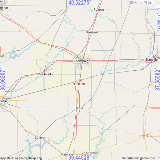
Tolono GPS coordinates[2]
39° 59' 10.104" North, 88° 15' 32.184" West
| Map corner | latitude | longitude |
|---|---|---|
| Upper-left | 40.52275°, | -88.96207° |
| Center: | 39.98614°, | -88.25894° |
| Lower-right: | 39.44528°, | -87.55582° |
| Map W x H: | 119.8×119.8 km | = 74.4×74.4mi |
| max Lat: | 71.29058° ⇑46.6% North |
| Tolono: | 39.98614° |
| min Lat: | ⇓53.4% South 19.06759° |
| min Long | Tolono | max Long |
| -171.73463° | -88.25894° | -66.98998° |
| W 46.1%⇐ | ⇒53.9% E |
Elevation
Elevation of Tolono is 224 m = 735 ft, and this is 70.8 m = 232 ft below average elevation for this country.
| Max E: |
3189 m = 10463 ft | 43.6% |
| Avg. | 294.8 m = 967 ft | |
| Tolono | 224 m = 735 ft | |
Min E: |
-60 m = -197 ft | 56.4% |
See also: United States elevation on elevation.city.
Geographical zone
Tolono is located in North temperate zone (between Tropic of Cancer and the Arctic Circle). Distance of this Northern Tropic circle is 1840.1 km =1143.4 mi to South.| Distance of | km | miles | from Tolono |
|---|---|---|---|
| North Pole | 5561 | 3455.4 | to North |
| Arctic Circle | 2955.1 | 1836.2 | to North |
| Tropic Cancer | 1840.1 | 1143.4 | to South |
| Equator | 4446 | 2762.6 | to South |


Nearby cities:
15 places around Tolono: (largest is in red/bold)
• Atwood
27 km =16.8 mi,  219°
219°
• Bement
27.6 km =17.1 mi,  255°
255°
• Champaign
14.5 km =9 mi,  5°
5°
• Homer
26.2 km =16.3 mi,  78°
78°
• Lake of the Woods
26.2 km =16.3 mi,  339°
339°
• Mahomet
26.3 km =16.3 mi,  332°
332°
• Monticello
27.2 km =16.9 mi,  279°
279°
• Pesotum
8 km =5 mi,  188°
188°
• Philo
8.9 km =5.5 mi,  74°
74°
• Saint Joseph
23.2 km =14.4 mi,  52°
52°
• Savoy
7.7 km =4.8 mi,  4°
4°
• Sidney
16.4 km =10.2 mi, 74°
• Tuscola
20.9 km =13 mi, 185°
• Urbana
14.5 km =9 mi,  17°
17°
• Villa Grove
16 km =9.9 mi,  148°
148°
Sources, notices
• [Note1] Compared only with cities in United States existing in our database
• [Src1] Map data: © OpenStreetMap contributors (CC-BY-SA)
• [Src2] Other city data from geonames.org with taken over terms of usage.
• [Src3] Geographical zone / Annual Mean Temperature by Robert A. Rohde @ Wikipedia
