Naperville geodata
Naperville (Illinois) is a populated place; located in United States in America/Chicago (GMT-5) time zone. With population of 147,100 people, there are 204 cities with bigger population in this country. Compared to other cities in United States, 73.8% of cities are located further ↓South; 53.5% of cities are located further →East and 54.7% of cities have lower elevation than Naperville. Note1
Administrative division(s):
- Level 1: Illinois
- Level 2: DuPage County
- Level 3: Township of Naperville


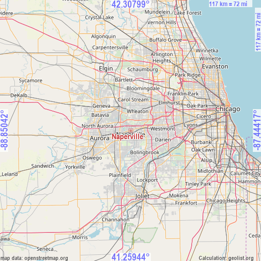
Naperville GPS coordinates[2]
41° 47' 9.096" North, 88° 8' 50.244" West
| Map corner | latitude | longitude |
|---|---|---|
| Upper-left | 42.30799°, | -88.85042° |
| Center: | 41.78586°, | -88.14729° |
| Lower-right: | 41.25944°, | -87.44417° |
| Map W x H: | 116.6×116.6 km | = 72.5×72.5mi |
| max Lat: | 71.29058° ⇑26.2% North |
| Naperville: | 41.78586° |
| min Lat: | ⇓73.8% South 19.06759° |
| min Long | Naperville | max Long |
| -171.73463° | -88.14729° | -66.98998° |
| W 46.5%⇐ | ⇒53.5% E |
Elevation
Elevation of Naperville is 217 m = 712 ft, and this is 77.8 m = 255 ft below average elevation for this country.
| Max E: |
3189 m = 10463 ft | 45.3% |
| Avg. | 294.8 m = 967 ft | |
| Naperville | 217 m = 712 ft | |
Min E: |
-60 m = -197 ft | 54.7% |
See also: Naperville elevation on elevation.city.
Geographical zone
Naperville is located in North temperate zone (between Tropic of Cancer and the Arctic Circle). Distance of this Northern Tropic circle is 2040.2 km =1267.7 mi to South.| Distance of | km | miles | from Naperville |
|---|---|---|---|
| North Pole | 5360.9 | 3331.1 | to North |
| Arctic Circle | 2755 | 1711.9 | to North |
| Tropic Cancer | 2040.2 | 1267.7 | to South |
| Equator | 4646.2 | 2887 | to South |


Nearby cities:
15 places around Naperville: (largest is in red/bold)
• Aurora
14.6 km =9.1 mi,  258°
258°
• Batavia
15.4 km =9.6 mi,  297°
297°
• Bolingbrook
11.7 km =7.3 mi,  145°
145°
• Carol Stream
14.1 km =8.8 mi,  4°
4°
• Darien
14.9 km =9.3 mi,  104°
104°
• Downers Grove
11.6 km =7.2 mi,  77°
77°
• Glen Ellyn
12.2 km =7.6 mi,  33°
33°
• Lisle
6.2 km =3.9 mi,  74°
74°
• North Aurora
15.1 km =9.4 mi,  278°
278°
• Warrenville
4.2 km =2.6 mi,  328°
328°
• West Chicago
12 km =7.5 mi,  336°
336°
• Westmont
14.3 km =8.9 mi,  85°
85°
• Wheaton
9.5 km =5.9 mi,  20°
20°
• Winfield
8.5 km =5.3 mi,  352°
352°
• Woodridge
9.1 km =5.7 mi,  118°
118°
Sources, notices
• [Note1] Compared only with cities in United States existing in our database
• [Src1] Map data: © OpenStreetMap contributors (CC-BY-SA)
• [Src2] Other city data from geonames.org with taken over terms of usage.
• [Src3] Geographical zone / Annual Mean Temperature by Robert A. Rohde @ Wikipedia
