Frankfort geodata
Frankfort (Indiana) is a seat of a second-order administrative division; located in United States in America/Indiana/Indianapolis (GMT-4) time zone. With population of 16,060 people, there are 3047 cities with bigger population in this country. Compared to other cities in United States, 56.4% of cities are located further ↓South; 51.5% of cities are located further ←West and 65% of cities have lower elevation than Frankfort. Note1


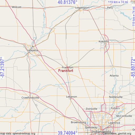
Frankfort GPS coordinates[2]
40° 16' 46.128" North, 86° 30' 39.024" West
| Map corner | latitude | longitude |
|---|---|---|
| Upper-left | 40.81376°, | -87.21397° |
| Center: | 40.27948°, | -86.51084° |
| Lower-right: | 39.74094°, | -85.80772° |
| Map W x H: | 119.3×119.3 km | = 74.1×74.1mi |
| max Lat: | 71.29058° ⇑43.6% North |
| Frankfort: | 40.27948° |
| min Lat: | ⇓56.4% South 19.06759° |
| min Long | Frankfort | max Long |
| -171.73463° | -86.51084° | -66.98998° |
| W 51.5%⇐ | ⇒48.5% E |
Elevation
Elevation of Frankfort is 262 m = 860 ft, and this is 32.8 m = 108 ft below average elevation for this country.
| Max E: |
3189 m = 10463 ft | 35% |
| Avg. | 294.8 m = 967 ft | |
| Frankfort | 262 m = 860 ft | |
Min E: |
-60 m = -197 ft | 65% |
See also: United States elevation on elevation.city.
Geographical zone
Frankfort is located in North temperate zone (between Tropic of Cancer and the Arctic Circle). Distance of this Northern Tropic circle is 1872.7 km =1163.6 mi to South.| Distance of | km | miles | from Frankfort |
|---|---|---|---|
| North Pole | 5528.4 | 3435.2 | to North |
| Arctic Circle | 2922.5 | 1816 | to North |
| Tropic Cancer | 1872.7 | 1163.6 | to South |
| Equator | 4478.7 | 2782.9 | to South |


Nearby cities:
15 places around Frankfort: (largest is in red/bold)
• Burlington
24.4 km =15.2 mi,  23°
23°
• Clarks Hill
18.5 km =11.5 mi,  258°
258°
• Colfax
16.3 km =10.1 mi,  234°
234°
• Darlington
29.1 km =18.1 mi, 229°
• Dayton
24.3 km =15.1 mi,  295°
295°
• Flora
29.8 km =18.5 mi,  357°
357°
• Kirklin
16 km =9.9 mi,  126°
126°
• Lebanon
25.9 km =16.1 mi,  172°
172°
• Monroe
19.1 km =11.9 mi,  272°
272°
• Mulberry
15 km =9.3 mi, 298°
• Rossville
16.9 km =10.5 mi,  335°
335°
• Russiaville
25.4 km =15.8 mi,  52°
52°
• Sheridan
29.4 km =18.3 mi,  123°
123°
• Stockwell
22.1 km =13.7 mi, 271°
• Thorntown
18.6 km =11.6 mi,  206°
206°
Sources, notices
• [Note1] Compared only with cities in United States existing in our database
• [Src1] Map data: © OpenStreetMap contributors (CC-BY-SA)
• [Src2] Other city data from geonames.org with taken over terms of usage.
• [Src3] Geographical zone / Annual Mean Temperature by Robert A. Rohde @ Wikipedia
