Garrett geodata
Garrett (Indiana) is a populated place; located in United States in America/Indiana/Indianapolis (GMT-4) time zone. With population of 6,344 people, there are 6193 cities with bigger population in this country. Compared to other cities in United States, 69.3% of cities are located further ↓South; 55.6% of cities are located further ←West and 67.2% of cities have lower elevation than Garrett. Note1


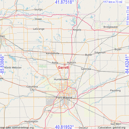
Garrett GPS coordinates[2]
41° 20' 58.164" North, 85° 8' 7.908" West
| Map corner | latitude | longitude |
|---|---|---|
| Upper-left | 41.87518°, | -85.83866° |
| Center: | 41.34949°, | -85.13553° |
| Lower-right: | 40.81952°, | -84.43241° |
| Map W x H: | 117.4×117.4 km | = 72.9×72.9mi |
| max Lat: | 71.29058° ⇑30.7% North |
| Garrett: | 41.34949° |
| min Lat: | ⇓69.3% South 19.06759° |
| min Long | Garrett | max Long |
| -171.73463° | -85.13553° | -66.98998° |
| W 55.6%⇐ | ⇒44.4% E |
Elevation
Elevation of Garrett is 272 m = 892 ft, and this is 22.8 m = 75 ft below average elevation for this country.
| Max E: |
3189 m = 10463 ft | 32.8% |
| Avg. | 294.8 m = 967 ft | |
| Garrett | 272 m = 892 ft | |
Min E: |
-60 m = -197 ft | 67.2% |
See also: United States elevation on elevation.city.
Geographical zone
Garrett is located in North temperate zone (between Tropic of Cancer and the Arctic Circle). Distance of this Northern Tropic circle is 1991.7 km =1237.6 mi to South.| Distance of | km | miles | from Garrett |
|---|---|---|---|
| North Pole | 5409.4 | 3361.2 | to North |
| Arctic Circle | 2803.5 | 1742 | to North |
| Tropic Cancer | 1991.7 | 1237.6 | to South |
| Equator | 4597.6 | 2856.8 | to South |


Nearby cities:
15 places around Garrett: (largest is in red/bold)
• Albion
24.6 km =15.3 mi,  282°
282°
• Ashley
20.5 km =12.7 mi,  16°
16°
• Auburn
6.7 km =4.2 mi,  73°
73°
• Avilla
8.8 km =5.5 mi, 281°
• Butler
23.8 km =14.8 mi, 67°
• Churubusco
20.3 km =12.6 mi,  229°
229°
• Fort Wayne
24.3 km =15.1 mi,  178°
178°
• Grabill
20.9 km =13 mi,  137°
137°
• Harlan
24.8 km =15.4 mi,  133°
133°
• Hudson
20.9 km =13 mi,  12°
12°
• Huntertown
13.8 km =8.6 mi,  192°
192°
• Kendallville
14.9 km =9.3 mi,  313°
313°
• Leo-Cedarville
18.2 km =11.3 mi,  146°
146°
• Rome City
25.9 km =16.1 mi, 309°
• Waterloo
13.3 km =8.3 mi,  46°
46°
Sources, notices
• [Note1] Compared only with cities in United States existing in our database
• [Src1] Map data: © OpenStreetMap contributors (CC-BY-SA)
• [Src2] Other city data from geonames.org with taken over terms of usage.
• [Src3] Geographical zone / Annual Mean Temperature by Robert A. Rohde @ Wikipedia
